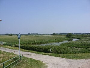
Vreschen-Bokel at Aper Tief
|
Vreschen-Bokel nature reserve at Aper Tief
|
||
|
Nature reserve "Vreschen-Bokel am Aper Tief" |
||
| location | south of Vreschen-Bokel in the Lower Saxony district of Ammerland | |
| surface | 104.4 ha | |
| Identifier | NSG WE 271 | |
| WDPA ID | 389991 | |
| Geographical location | 53 ° 13 ' N , 7 ° 43' E | |
|
|
||
| Sea level | from -3 m to 0 m | |
| Setup date | February 21, 2009 | |
| administration | NLWKN | |
Vreschen-Bokel am Aper Tief is the name of a nature reserve in the Lower Saxon community of Apen in the Ammerland district .
The nature reserve with the registration number NSG WE 271 is 104.4 hectares . The nature reserve, which is located southwest of the village of Augustfehn , is a grassland complex that is criss-crossed by oxbow lakes from the Aper Tief . The grassland areas in the nature reserve are mainly used as hay meadows . It is planned to relocate the dike and to dike part of the area.
In the southwest of the nature reserve there is a sand mining area that is still used. A lake was created here through the sand mining.
In the west, the nature reserve borders on the approximately 200 hectare high water polder " Detern-Oversized Lowland ", which is located south of the Aper Tief as far as its confluence with the Jümme .
The area has been a nature reserve since February 21, 2009. The responsible lower nature conservation authority is the district of Ammerland.


