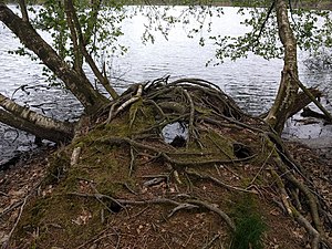
Godensholter Tief (nature reserve)
|
Godensholter low
|
||
|
At the Drakamp-Schlatt |
||
| location | East of Barßel , Cloppenburg and Ammerland districts , Lower Saxony | |
| surface | 93 ha | |
| Identifier | NSG WE 285 | |
| WDPA ID | 555690867 | |
| FFH area | 85 ha | |
| Geographical location | 53 ° 10 ' N , 7 ° 50' E | |
|
|
||
| Sea level | from 1.5 to 5.5 | |
| Setup date | 1st January 2018 | |
The Godensholter Tief is a nature reserve in the Lower Saxony communities of Barßel in the district of Cloppenburg and Apen in the district of Ammerland .
The nature reserve with the registration number NSG WE 285 is around 93 hectares in size. About 81 hectares are in the district of Cloppenburg, 12 hectares in the district of Ammerland. The 85 hectare FFH area of the same name is part of the nature reserve. The area has been under nature protection since January 1, 2018. Responsible lower nature conservation authorities are the districts of Cloppenburg and Ammerland.
The nature reserve is east of Barßel. It represents a section of the valley of the eponymous Godensholter lows with remains adjacent, glacial inland dunes under protection. The lowlands are predominantly characterized by moist fen soils with grassland used as pasture or hay meadow . There are also reeds and moist tall herbaceous vegetation . In parts, alluvial forest remains , forest parcels and groups of trees dominated by alder and ash . In places there are backwaters of the Godensholter Tief. At the edge of the nature reserve is the approximately two hectare Drakamp-Schlatt, which was created in a blow-out basin and is designated as a natural monument . The Schlatt is surrounded by woods and borders the Loher Forest, south of the nature reserve. Typical moor plants such as peat moss , sundew, sedges, swamp blood-eye and gagelstrauch settle on the banks of the Schlatt .
The nature reserve is bordered in places of public road and rural roads . In the northwest it borders on the embankment of the Cloppenburg – Ocholt railway line . The county road 299 of Godensholt to national road 832 crosses the area.
Web links
- Godensholter Tief in the database of the Lower Saxony State Office for Water Management, Coastal and Nature Conservation (NLWKN)
Individual evidence
- ↑ Securing the FFH area "Godensholter Tief" - agreement on the ordinance issued by the Ammerland district, Ammerland district, September 4, 2017. Accessed January 10, 2018.
- ^ Godensholter Tief , Profiles of the Natura 2000 areas, Federal Agency for Nature Conservation . Retrieved January 10, 2018.
- ↑ "Drakamp-Schlatt" natural monument , Das Radland. Retrieved January 10, 2018.
- ↑ Hans Passmann: Discussions about human intervention in nature , Nordwest-Zeitung , May 31, 2016. Accessed January 10, 2018.
- ^ Excursion to the Loher Forest , Nordwest-Zeitung, August 18, 2006. Accessed January 10, 2018.


