Araguatins
| Município de Araguatins Araguatins |
||
|---|---|---|
|
Igreja Matriz de Araguatins
|
||
|
|
||
| Coordinates | 5 ° 39 ′ S , 48 ° 7 ′ W | |
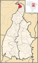
 Location of Araguatins in the state of Tocantins Location of Araguatins in the state of Tocantins
|
||
| Symbols | ||
|
||
| founding | June 9, 1868 (as Vila de São Vicente do Araguaia) | |
| Basic data | ||
| Country | Brazil | |
| State | Tocantins | |
| ISO 3166-2 | BR-TO | |
| Região intermediária | Araguaína (since 2017) | |
| Região imediata | Araguatins (since 2017) | |
| Mesoregion | Ocidental do Tocantins (1989 to 2017) | |
| Microregion | Bico do Papagaio (1989 to 2017) | |
| height | 103 m | |
| climate | Aw, tropical | |
| surface | 2,625.3 km² | |
| Residents | 31,329 (2010) | |
| density | 11.9 Ew. / km² | |
| estimate | 35,761 Ew. (July 1, 2019) | |
| Parish code | IBGE : 1702208 | |
| Time zone | UTC −3 | |
| Website | araguatins.to (Brazilian Portuguese) | |
| politics | ||
| City Prefect | Claudio Carneiro Santana (2017-2020) | |
| Political party | PMDB | |
| Culture | ||
| Patron saint | Sao Vicente Ferrer | |
| economy | ||
| GDP | 377,258 thousand R $ 10,838 R $ per capita (2016 (Preços Correntes e Colocação)) |
|
| HDI | 0.631 (2010) | |
Araguatins , officially Município de Araguatins , is the sixth largest city in the Brazilian state of Tocantins in the Região Norte . It is 601 km from the capital of Palma . The population was estimated on July 1, 2019 at 35,761 inhabitants, called Araguatinese (Portuguese araguatinenses ), who live in an area of around 2625 km². The population density is 13 people per km².
history
The place was initially called São Vicente do Araguaia . Until 1989 it belonged to the state of Goiás .
Standard of living
The human development index for cities, abbreviated HDI (Portuguese: IDH-M ), was in 1991 at the low value of 0.301, in 2010 at the value classified as medium of 0.631.
Sons and daughters
- Francisco Lima Soares (* 1964), Roman Catholic clergyman, Bishop of Carolina
literature
- Secretaria do Planejamento e Orçament (SEPLAN): Porto Nacional 2017 . Ed .: Governo do Estado do Tocantins (= Perfil Socioeconômico dos Municípios ). Palmas 2017 (Brazilian Portuguese, online [PDF]).
Web links
Commons : Araguatins - collection of images, videos and audio files
- City Prefecture website , Prefeitura Municipal (Brazilian Portuguese)
- City Council website , Câmara Municipal (Brazilian Portuguese)
Individual evidence
- ↑ a b c d Instituto Brasileiro de Geografia e Estatística (IBGE): Tocantins Panorama. Retrieved September 8, 2019 (Brazilian Portuguese).
- ^ A b Atlas do Desenvolvimento Humano do Brasil: Araguatins. Retrieved January 21, 2018 (Brazilian Portuguese).
- ^ Cidade - Histórico. In: gov.br. Prefeitura Municipal de Araguatins, accessed January 21, 2018 (Brazilian Portuguese).


