
Araucária
| Município de Araucária Araucária |
|||
|---|---|---|---|

Brazilian pine : eponym and important economic factor
|
|||
|
|||
| Coordinates | 25 ° 36 ′ S , 49 ° 25 ′ W | ||
 Location of Araucária in the state of Paraná Location of Araucária in the state of Paraná
|
|||
| Symbols | |||
|
|||
| founding | February 11, 1890 | ||
| Basic data | |||
| Country | Brazil | ||
| State | Paraná | ||
| ISO 3166-2 | BR-PR | ||
| Mesoregion | Metropolitana de Curitiba | ||
| Microregion | Curitiba | ||
| structure | 2 districts: Araucária and Guajuvira with 58 bairros | ||
| height | 897 m | ||
| Waters | Rio Iguaçu | ||
| surface | 469.2 km² | ||
| Residents | 119,123 (2010) | ||
| density | 253.9 Ew. / km² | ||
| estimate | 143,843 Ew. (July 1, 2019) | ||
| Parish code | IBGE : 4101804 | ||
| Time zone | UTC −3 | ||
| politics | |||
| City Prefect | Hissam Hussein Dehaini (2017-2020) | ||
| Political party | PPS | ||
| economy | |||
| GDP | 16,978,801 thousand R $ 125,343 R $ per person (2016) |
||
| HDI | 0.740 (2010) | ||


Araucária , officially Município de Araucária , is a city in the Brazilian state of Paraná . It was founded on February 11, 1890 and in 2010 had 119,123 inhabitants, who are called Araucarianos. The population was estimated at 143,843 as of July 1, 2019. It is located close to the capital Curitiba , from which it is 27 km away.
Origin of name
The name is derived from the tree species Auraukarie (Araucária), which form extensive araucaria forests . The seeds of the cones served the Indians roasted as food and they are still used by the population today.
history
In 1668 the captain general and bandeirante Gabriel de Lara distributed the first sesmarias in the area of today's Araucária to Domingos Rodrigues da Cunha and his sons Luís Rodrigues Velho and Garcia Rodrigues Velho. They called the first settlement Tindiqüera . It attracted more settlers, including the Maia family, who were expelled from Curitiba and later important entrepreneurs. In 1853 the province of Paraná was founded with the nearby Curitiba as its capital. In 1855 the church district Freguesia de Nossa Senhora dos Remédios do Yguassú (Freguesia do Iguassu) was established, from 1876 onwards colonists mainly from Poland, Russia and Germany increased the population.
On February 2, 1890, the place was raised to a Município with the name Araucária during area reforms of the now founded state Paraná and the area was spun off from Curitiba and São José dos Pinhais . The decree came into effect on March 1, 1890, after the first chamber of city councils (city council) was installed. The district town initially only consisted of the district of the same name. On October 10, 1947, the second district of Guajuvira was formed and assigned to the city.
geography
The city is located on the First Paranaian Plateau between the Serra do Mar and the Planalto de Ponta Grossa on the banks of the Rio Iguaçu . The climate is subtropical and according to the Köppen-Geiger climate classification : Cfb .
City administration
After the local elections in 2012, Olizandro José Ferreira of the Partido do Movimento Democrático Brasileiro (PMDB ) was after the local elections in 2012 for the term of office 2013 to 2016 ; after the local elections in 2016, Hissam Hussein Dehaini of the Partido Popular Socialista (PPS) for the term of office 2017 to 2020 elected as the incumbent city prefect.
The legislature lies with the Câmara Municipal, the city council made up of 11 city councilors. The place is also the seat of the district of the same name, the second district is Guajuvira. The large administrative area is divided into a further 19 urban and 39 rural bairros. The urban area is about 30%.
Together with 18 other municipalities, it formed the Curitiba microregion until 2017 , which was one of five microregions of the Metropolitana de Curitiba mesoregion .
Population development

Ethnic groups
The first population consisted of the Portuguese-born Brazilians, Indians and blacks. This was followed by the immigration of Poles, Italians, Ukrainians, Syrians, Lebanese, Germans and Japanese, particularly caused by the advancing industrialization of the 1970s.
(As of 2010 with 119,123 inhabitants)
| group | proportion of | in % | annotation |
|---|---|---|---|
| Pardos (mixed race) | 31,614 | 32.96 | mostly mulattos and mestizos |
| Pretos ( blacks ) | 4,471 | 4.18 | |
| Brancos (whites, descendants of Europeans ) | 82,266 | 61.92 | |
| Asians | 639 | 0.21 | |
| Indigenous people | 132 | 0.73 |
Source:
economy
Already in colonial times there was extensive timber industry, the araucarias were cleared quickly and the wood was mainly used in shipbuilding and as construction timber . With the introduction of the railway and the expansion of the roads, later for large trucks, between 1870 and the 1940s, the primeval forests in the municipal area were rapidly destroyed, which was partially offset by forest cultures. The wood is mainly used today for furniture construction, as industrial wood and also for making musical instruments. The area was also suitable for the booming yerba mate cultivation from the middle of the 19th century until the export opportunities for mate tea subsided. Other branches of industry such as ceramics, mill products, the manufacture of wooden boxes, paper mills, linen or coffee roasters emerged.
Industrialization began in the 1970s, including the settlement of the petrochemical Refinaria Presidente Getúlio Vargas in 1973 by the Petrobras . The gross domestic product per capita in Araucária was 104,568 reais in 2015 , which is above average in Brazil. The GDP for Araucária in 2015 was 13,952,249,000 reais.
tourism
One of the sights is the Parque Cachoeira (waterfall park), which offers an artificial lake on around 28 hectares, fed by the Ribeirão Chimbituva, a tributary of the Iguaçu. The nature park contains araucaria forests with different species, plus a species-rich fauna. The Museu Tingüi-Cuera , a local history museum, is located in the recreation area, which is only open during the day .
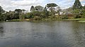
Parque Cachoeira

Sports
The Araucária Futebol Clube played in 2002 in the third division of the Paraná State Championship .
literature
- Instituto Paranaense de Desenvolvimento Econômico e Social (IPARDES): Caderno estatística Município de Araucária. August 2016.
Web links
- City Prefecture website (Brazilian Portuguese)
- Câmara Municipal website (Brazilian Portuguese)
- IBGE: Cidades @ Paraná: Araucária> Panorama , information from the statistical institute (Brazilian Portuguese)
- Araucária no Ar website (Brazilian Portuguese)
Individual evidence
- ↑ a b c IBGE : Cidades @: Araucária> Panorama. Retrieved November 29, 2019 (Brazilian Portuguese).
- ↑ a b Hissam 23 (Prefeito). In: com.br. Eleições 2016, accessed January 18, 2018 .
- ^ Araucária: Histórico .
- ↑ Eleições 2012: Olizandro 15 on the website www.eleicoes2012.info [accessed on August 11, 2016 (Portuguese)].
- ↑ Instituto Paranaense de Desenvolvimento Econômico e Social (IPARDES): Caderno estatística Município de Araucária. August 2016, p. 14 (Brazilian Portuguese).