Arnhofen (Abensberg)
|
Arnhofen
City of Abensberg
Coordinates: 48 ° 50 ′ 7 ″ N , 11 ° 52 ′ 39 ″ E
|
||
|---|---|---|
| Residents : | 336 (May 25 1987) | |
|
Location of Arnhofen in Bavaria |
||
|
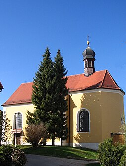
Filial church of St. Stephen
|
||
The village of Arnhofen is a district of the town of Abensberg in the Kelheim district , Lower Bavaria . Until 1972 it formed an independent municipality.
location
The church village is located in the southern foothills of the Jura , on the western slope of a wide dry valley, which was once created by the ice age primeval evening flowing northwards over the Hopfenbach valley into the Kelheim valley basin . Regensburg is about 35 km to the east, Ingolstadt 40 km to the west. Munich is about 95 km south of the town.
history
In the 1980s, a Neolithic mine was discovered near the place . Between 5000 and 4000 BC were built here. Christ the Neolithic miners on 10 hectares and in more than 20,000 shafts from flint . The Abensberg-Arnhofen flint mine , one of the largest of its kind in Central Europe, is a mining archaeological ground monument of international importance.
In a document, Arnhofen appeared as "Arnhelmahova" (= Arnhelm's court) as early as 867. The local family of the "Arinhofer" is documented until the end of the 14th century. In 1760 the Abensberg Carmelites owned a large part of Arnhofen.
When the town was incorporated into the town of Abensberg as part of the regional reform , Arnhofen lost its political independence on January 1, 1972.
Architectural monuments
See also: List of architectural monuments in Arnhofen
- The branch church St. Stephanus was rebuilt in 1753.
Economy and Infrastructure
In the village with around 550 inhabitants, in which residential areas have now also been designated, extensive agriculture is still practiced. Arnhofen is on the Regensburg – Ingolstadt railway line and until 1980 had its own train station. A medium-sized brick factory was located on the spot. Arnhofen belongs to the district of the parish Pullach .
societies
- Arnhofen volunteer fire brigade
- Horticultural Association Pullach-Arnhofen
- Catholic rural youth Pullach-Arnhofen
- Warrior and Comrade Association Pullach-Arnhofen
- Jennerwein shooting club
- Arnhofen hunting association
- SV 72 Arnhofen
Web links
- Arnhofen on the homepage of the city of Abensberg (last accessed on October 29, 2012)
Individual evidence
- ↑ Bavarian State Office for Statistics and Data Processing (Ed.): Official local directory for Bavaria, territorial status: May 25, 1987 . Issue 450 of the articles on Bavaria's statistics. Munich November 1991, DNB 94240937X , p. 181 ( digitized version ).
- ↑ Geological Institutes of the Universities of Vienna and Bern ( page no longer available , search in web archives ) Info: The link was automatically marked as defective. Please check the link according to the instructions and then remove this notice. (last accessed on October 29, 2012; PDF; 1.4 MB)
- ↑ a b c Georg Rieger, Kelheimer Heimatbuch for the city and the district of Kelheim, 1953, pages 263–264.
- ^ Wilhelm Volkert (ed.): Handbook of Bavarian offices, communities and courts 1799–1980 . CH Beck, Munich 1983, ISBN 3-406-09669-7 , p. 493 .


