Atur
| Atur | ||
|---|---|---|
|
|
||
| local community | Boulazac Isle Manoire | |
| region | Nouvelle-Aquitaine | |
| Department | Dordogne | |
| Arrondissement | Périgueux | |
| Coordinates | 45 ° 8 ′ N , 0 ° 45 ′ E | |
| Post Code | 24750 | |
| Former INSEE code | 24013 | |
| Incorporation | January 1, 2016 | |
| status | Commune déléguée | |
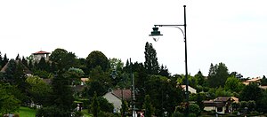
 View of the center of Atur |
||
Atur ( Occitan : Astur ) is a village and a commune déléguée in the French commune of Boulazac Isle Manoire with 1,936 inhabitants (as of January 1, 2017) in the Dordogne department in the Nouvelle-Aquitaine region . The inhabitants are called Aturiens .
With effect from January 1, 2016, the former municipalities of Atur , Boulazac and Saint-Laurent-sur-Manoire were merged and have since formed the Commune nouvelle Boulazac Isle Manoire. The municipality of Atur was part of the Arrondissement of Périgueux and the canton of Isle-Manoire (until 2015: canton of Saint-Pierre-de-Chignac )
geography
Atur is located around five kilometers southeast of the city center of Périgueux in the Périgord countryside on the Cerf River . The A89 car route runs through the area .
Population development
| year | 1962 | 1968 | 1975 | 1982 | 1990 | 1999 | 2006 | 2012 |
| Residents | 517 | 560 | 836 | 1,082 | 1,248 | 1,491 | 1,668 | 1,874 |
| Source: Cassini and INSEE | ||||||||
Attractions
- Notre-Dame-de-l'Assomption church, Romanesque building from the 12th / 13th centuries. Century, bell tower from the 14th century, monument historique since 1947
- Death lantern from the 12th century
- Lafaye Castle
- Le Breuilh Castle from the 15th century, alterations and additions in the 17th century
- Beauvigier Castle
- Pommier Castle
- Mazardie pigeon tower
Community partnerships
A partnership had existed with the Belgian municipality of Yvoir in the province of Namur (Wallonia) since 1990.


