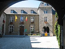
Yvoir
| Yvoir | ||
|---|---|---|

|

|
|
|
|
||
| State : |
|
|
| Region : | Wallonia | |
| Province : | Namur | |
| District : | Dinant | |
| Coordinates : | 50 ° 20 ' N , 4 ° 53' E | |
| Area : | 56.84 km² | |
| Residents: | 9167 (Jan 1, 2019) | |
| Population density: | 161 inhabitants per km² | |
| Post Code: | 5530 | |
| Prefix: | 082 | |
| Mayor: | Ovide Monin | |
Local government address : |
Administration Communale Rue l'Hôtel de Ville, 1 5530 Yvoir |
|
| Website: | www.yvoir.be | |
Yvoir is a municipality in the province of Namur in the Walloon part of Belgium .
The municipality lies on the right side of the Meuse and consists of the districts of Yvoir, Dorinne, Durnal, Evrehailles, Godinne, Houx, Mont, Purnôde and Spontin.
In the district of Mont-Godinne there is a teaching hospital of the University Clinic of the Catholic University of Louvain-la-Neuve .
Spontin Castle is in the Spontin district .
traffic
The railway Athus-Meuse line connects the agglomeration of Namur at the Maas (= Meuse) with the Belgian Ardennes locations Dinant , Virton , Athus and Arlon . From these locations routes continue to France and Luxembourg .
From Yvoir to Ciney there is a museum railway called Le Chemin de fer du Bocq .
Sports
In 1975 the road cycling world championship took place in Yvoir.
Others
A period of the Carboniferous , Ivorian , is named after the place Yvoir.
The Belgian granite , a gray-blue to charcoal-gray limestone was mined in eastern Bocq valley from Yvoir and under the name of Petit du Bocq granite sold.
Web links
- Official website of the municipality of Yvoir (French, Dutch, English)
- Website UCL University Clinics of Mont-Godinne (English)


