Fernelmont
| Fernelmont | ||
|---|---|---|

|

|
|
|
|
||
| State : |
|
|
| Region : | Wallonia | |
| Province : | Namur | |
| District : | Namur | |
| Coordinates : | 50 ° 33 ' N , 4 ° 59' E | |
| Area : | 65.61 km² | |
| Residents: | 8032 (Jan. 1, 2019) | |
| Population density: | 122 inhabitants per km² | |
| Post Code: | 5380 | |
| Prefix: | 081 | |
| Mayor: | Jean-Claude Nihoul | |
Local government address : |
Administration Communale Rue Goffin, 2 5380 Noville-les-Bois |
|
| Website: | www.fernelmont.be | |
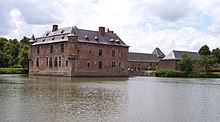
Fernelmont is a francophone Belgian municipality in the Wallonia region with 8032 inhabitants (as of January 1, 2019). The municipality is located north of the Maas and consists of the ten districts Bierwart, Cortil-Wodon, Forville, Franc-Waret, Hemptinne, Hingeon, Marchovelette, Noville-les-Bois, Pontillas and Tillier. It takes its name after a castle, the Château de Fernelmont , which was built in the 13th century by Godescalc de Fernelmont .
Namur is 13 kilometers southwest, Liège 40 kilometers east-northeast and Brussels a good 52 kilometers northwest (all information as the crow flies ).
The next motorway exits are Fernelmont on the A 15 / E 42 and Éghezée on the A 4 / E 411 .
In Andenne , Namêche and Rhisnes are the next regional stations , and in Namur keep on regional express trains.
The Brussels-Charleroi airport and the airport of Liege are the next regional airports with international connections also, and the airport Brussels National near the capital Brussels is an international Airport.


