Vresse-sur-Semois
| Vresse-sur-Semois | ||
|---|---|---|

|

|
|
|
|
||
| State : |
|
|
| Region : | Wallonia | |
| Province : | Namur | |
| District : | Dinant | |
| Coordinates : | 49 ° 52 ′ N , 4 ° 56 ′ E | |
| Area : | 101.04 km² | |
| Residents: | 2615 (Jan. 1, 2019) | |
| Population density: | 26 inhabitants per km² | |
| Post Code: | 5550 | |
| Prefix: | 061 | |
| Mayor: | Bruno Tellier ( CDH ) | |
Local government address : |
Administration Communale Rue Albert Raty, 112 5550 Vresse-sur-Semois |
|
| Website: | www.vresse-sur-semois.be | |
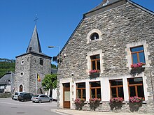
Vresse-sur-Semois is a municipality in the province of Namur in the Walloon part of Belgium .
In Vresse, besides French , the regional language Champenois , recognized in Wallonia, is spoken.
geography
Vresse is located in the Ardennes on the Semois , a river that flows in numerous loops towards France and there flows into the Meuse from the right . The distance to the border with France is a few kilometers.
The municipality consists of the districts of Vresse, Alle, Bagimont, Bohan, Chairière, Laforêt, Membre, Mouzaive, Nafraiture, Orchimont, Pussemange and Sugny . The district of Laforêt is one of the most beautiful villages in Wallonia .
Neighboring municipalities are (clockwise from the north): Gedinne and Bièvre and Bouillon in Belgium and Fleigneux , Bosseval-et-Briancourt , Donchery , Saint-Menges , Les Hautes-Rivières and Gespunsart in France.
Community partnerships
The partner municipalities of Vresse-sur-Semois have been Middelkerke in the Belgian province of West Flanders since 1992 and Soultzmatt-Wintzfelden in Alsace (France) since 2012 .

