
Bouillon (Belgium)
| bouillon | |||
|---|---|---|---|

|

|
||
|
|||
| State : |
|
||
| Region : | Wallonia | ||
| Province : | Luxembourg | ||
| District : | Neufchâteau | ||
| Coordinates : | 49 ° 48 ' N , 5 ° 4' E | ||
| Area : | 149.09 km² | ||
| Residents: | 5411 (Jan. 1, 2019) | ||
| Population density: | 36 inhabitants per km² | ||
| Post Code: | 6830-6834, 6836, 6838 | ||
| Prefix: | 061 | ||
Local government address : |
Place Ducale 1 6830 Bouillon |
||
| Website: | www.bouillon.be | ||

Bouillon (German rare / uncommon bumps , also Bulen ) is a municipality with 5411 inhabitants (as of January 1, 2019) in the south-east of Belgium in the Walloon region , right on the French border. The city lies on the banks of the Semois (German Sesbach ) in the Ardennes (the Ardennes are the western part of the Rhenish Slate Mountains ). The townscape is dominated by the castle of the same name .
Sons and daughters of the church
- Philippe Albert (* 1967), football player
- Léon Degrelle (1906–1994), leader of the Belgian Rexists and officer of the Waffen SS
- Ida of Lorraine (around 1040–1113), mother of Godfrey of Bouillon and saint of the Catholic Church
- Madeleine Ozeray (1908–1989), theater and film actress

Bouillon on the Semois
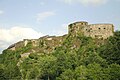
The castle Bouillon

Old map of the city and the castle
.jpg)
;_vue_de_la_partie_occidentale_du_ch%C3%A2teau-fort_(XIIIe%E2%80%93XIX_si%C3%A8cles).jpg)

Web links
Commons : Bouillon - collection of images, videos and audio files