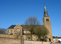
Florenville
| Florenville | ||
|---|---|---|

|

|
|
|
|
||
| State : |
|
|
| Region : | Wallonia | |
| Province : | Luxembourg | |
| District : | Virton | |
| Coordinates : | 49 ° 42 ' N , 5 ° 19' E | |
| Area : | 146.91 km² | |
| Post Code: | 6820-6824 | |
| Prefix: | 061 | |
| Website: | www.florenville.be | |
Florenville is a municipality with about 5500 inhabitants in the south-east of Belgium in the Walloon Region . The city lies on a hill, on the banks of the Semois (German Sesbach ).
traffic
The community has a train station on the Athus – Libramont railway line .
Attractions
It is known to Orval Abbey , originally built in the 12th century. In addition to the ruins, a new monastery was built on the cellars of the new baroque building from the 18th century from 1926, which is also known for its Trappist beer.
Web links
Commons : Florenville - collection of pictures, videos and audio files

