
Tellin
| Tellin | |||
|---|---|---|---|

|

|
||
|
|||
| State : |
|
||
| Region : | Wallonia | ||
| Province : | Luxembourg | ||
| District : | Neufchâteau | ||
| Coordinates : | 50 ° 5 ' N , 5 ° 13' E | ||
| Area : | 56.64 km² | ||
| Residents: | 2432 (Jan. 1, 2019) | ||
| Population density: | 43 inhabitants per km² | ||
| Post Code: | 6927 | ||
| Prefix: | 084 | ||
Local government address : |
Administration Communale Rue de la Liberation, 45 6927 Tellin |
||
| Website: | www.tellin.be | ||

Tellin is a Belgian city and municipality in the Neufchâteau arrondissement in the province of Luxembourg .
The community consists of the districts Tellin, Bure, Grupont and Resteigne. There is a church in every district, for example in Grupont St. Denise and Tellin St. Lambert .
Attractions
- Bell and Carillon Museum
- Churches
- Wind farm project

Spanish house in Grupon
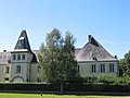
Castle in Resteigne

View from Val des Cloches, Tellin
.JPG)
.JPG)

Web links
Commons : Tellin - collection of pictures, videos and audio files
Commons : Bure - collection of images, videos and audio files