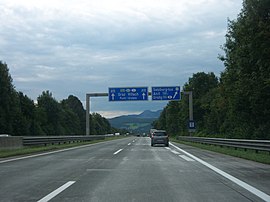
Motorway junction Salzburg-Süd
| Salzburg-South | |
|---|---|
|
|
|
| location | |
| Country: | Austria |
| State : | State of Salzburg |
| Coordinates: | 47 ° 44 '23 " N , 13 ° 3' 12" E |
| Bridges: | 1 (other) |
| Construction year: | 1941 |
| Last modification: | 2011/2012 |
| A10 - just before the exit | |
Salzburg-Süd is a motorway junction of the Austrian Tauern motorway (A10) located in the municipality of Anif . It has the numbering Exit 8 and is at motorway kilometers 4.9. Salzburg-Süd is the only and most distant motorway junction to the city of Salzburg between the German-Austrian border and towards Villach .
history
On September 13, 1941, the first two motorway sections of the Nazi Reichsautobahn in the "Ostmark" were released: from the temporary junction in Schwarzbach, about 0.7 km west of the border between Bavaria and Austria at the Walserberg to Salzburg-Mitte and from the junction Salzburg to the Salzburg Süd motorway junction near Anif and Grödig . By 1942, the sections to the Salzburg-Süd junction (now part of the Tauern Autobahn) and to Salzburg-Mitte (now part of the West Autobahn ) had been completed with a total of 13 kilometers. After that the construction work was stopped due to the war.
In 1968 the planning and continuation of the motorway route to the south as the Tauern motorway A 10 began again. Until the opening of the first section, the motorway officially ended with the motorway junction Salzburg-Süd. However, you could drive a few hundred meters further to the point where the Maximarkt Anif is located today .
In 2011/2012 the junction was structurally renewed, with the bridge over the motorway dating from the 1940s being demolished and replaced by a prestressed concrete bridge.
traffic
Traffic volume
According to ASFINAG traffic statistics, the Salzburg-Süd junction was frequented by an average of around 87,000 vehicles every day on weekdays; On Fridays and Saturdays the daily average was 96,300 and 95,000 vehicles, respectively. There were around 78,300 vehicles on Sundays and public holidays. The traffic to the north was slightly higher than in the opposite direction.
links
At the Salzburg-Süd exit, the only 3.1 km long Berchtesgadener Straße (B160) , a Salzburg state road, begins southwards and takes a short distance to the Bavarian communities of Marktschellenberg and Berchtesgaden . In the other direction, the junction forms the southern end of Salzburger Straße (B150) , which here also forms the continuation of the Alpenstraße starting in the city of Salzburg . From the junction you can go north to the villages of Anif and Niederalm and after a good 4 km to the southern city limits of Salzburg. It is another 4 km to the city center. With the exit Salzburg-Süd you can quickly reach the municipality of Grödig as well as Taxach and Rif , the northernmost parts of the municipality of Hallein .
Web links
- Motorway junction Salzburg-Süd in the local Salzburg Wiki
Individual evidence
- ↑ Traffic statistics August 2018. September 11, 2018, accessed on October 13, 2018 .
| Previous ASt. (Exit) |
Tauern Autobahn |
Next ASt. (Exit) |
|---|---|---|
|
Salzburg |
Salzburg South (8) |
Puch / Urstein (11) |
