Auzon (Ardèche)
| Auzon | ||
|
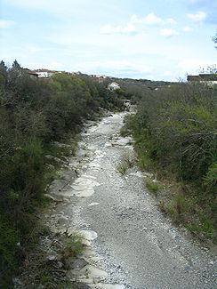
Lower reaches of the Auzon in complete dryness |
||
| Data | ||
| Water code | FR : V5020500 | |
| location | France , Ardeche department , Auvergne-Rhône-Alpes region | |
| River system | Rhône | |
| Drain over | Ardèche → Rhône → Mediterranean | |
| source | at Freyssenet 44 ° 41 ′ 4 ″ N , 4 ° 32 ′ 26 ″ E |
|
| Source height | 820 m | |
| muzzle | at Lanas in the Ardèche coordinates: 44 ° 31 ′ 42 " N , 4 ° 24 ′ 1" E 44 ° 31 ′ 42 " N , 4 ° 24 ′ 1" E |
|
| Mouth height | 138 m | |
| Height difference | 682 m | |
| Bottom slope | 26 ‰ | |
| length | 26 km | |
The Auzon is a karst river in the Cevennes , France . It rises on the Plateau du Coiron near Freyssenet and runs generally in a south-easterly direction and flows into the Ardèche after 26 kilometers at Lanas as a left tributary . Most of the year the Auzon is completely dry; after heavy rainfall, massive amounts of water can tumble through the river bed.
