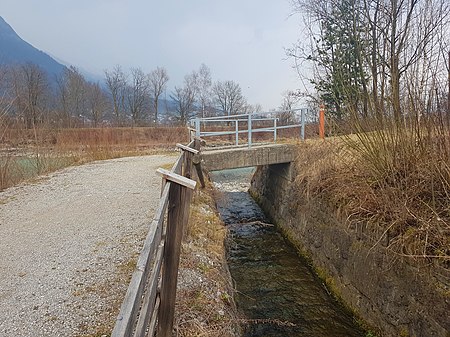
Axamer Bach
| Axamer Bach | ||
|
Flowers adorn the sea wall in the Axam district of Dornach |
||
| Data | ||
| Water code | AT : 2-8-141 | |
| location | Tyrol , Austria | |
| River system | Danube | |
| Drain over | Inn → Danube → Black Sea | |
| source | in the Axamer Lizum 47 ° 11 ′ 19 ″ N , 11 ° 18 ′ 12 ″ E |
|
| Source height | 1639 m above sea level A. | |
| muzzle | near Fiè in the Inn Coordinates: 47 ° 15 ′ 20 ″ N , 11 ° 19 ′ 57 ″ E 47 ° 15 ′ 20 ″ N , 11 ° 19 ′ 57 ″ E |
|
| Mouth height | 577 m above sea level A. | |
| Height difference | 1062 m | |
| Bottom slope | 93 ‰ | |
| length | 11.4 km | |
| Catchment area | 25.6 km² | |
| Communities | Axams , Birgitz , Völs | |
The Axamer Bach , formerly called Wildenbach , is an 11 km long right tributary of the Inn in Tyrol.
course
The Axamer Bach rises in the Axamer Lizum at an altitude of around 1640 m above sea level. A. and flows in a northerly direction until it reaches the valley floor of the Lizum. On the way he takes the Grubenbach from the left and the Halslbach and the Slalombach from the right. Below the Lizum flows an approximately 3.5 km long Kerbtal (Axamer Valley). Many feeders flow here from both sides, the most important are the Warmbachl and the Garaggabachl from the right. South of Axams he reaches the terrace of the low mountain range , where he has raised an alluvial cone on which the old town center of Axams lies. Below it, it has dug itself into the low mountain range and runs northeast through the Nasse Valley into the Inn Valley . There it crosses Völs and flows into the Inn from the right.
The gradient above the Lizum is around 30%, in the valley above Axams it is a fairly uniform 16%, then it decreases continuously and is around 2% at the mouth.
Catchment area
The Axamer Bach drains the Lizum, parts of the western low mountain range and the Nasse Valley. Its catchment area is 25.6 km², the highest point in it is the Marchreisenspitze at 2620 m above sea level. A.
Between the Lizum Axams and the catchment area is nearly pure stands of spruce forested, to the tree line at about 1800 to 1900 m , there are larch , spruce and pine , above alpine grass and dwarf shrub heath .
Floods and construction
The catchment area of the Axamer Bach lies to the windward side of northwest currents, which reach the Inntal via the Seefelder Sattel and rain down in front of the Kalkkögel , which can lead to high levels of precipitation and thus to floods and mudslides through the brook. In the past, houses were repeatedly destroyed and fields devastated. In 1974 the creek in the local area of Axams was built in a canal-like manner, in 1981 a bed load barrier was built at the gorge exit above Axams . In one of the most serious mudslides on July 4, 1983, severe erosion and mudsling occurred in the town center below the barrier, and around 50 houses were damaged, some severely. In the following year, the section between the bed load barrier and the site was also regulated.
Economic use
In the past, the water power of the Axamer Bach was used for numerous mills, especially for flax processing, forges and sawmills. Today it is used for a diversion power plant with a saw and for water extraction for irrigation and snow-making in the Axamer Lizum. The municipality of Axams is planning a power plant that will, among other things, supply the Lizum with electricity.
sport and freetime
Roads, footpaths or forest paths run along the entire length from the Axamer Lizum to the mouth of the Inn in the immediate vicinity of the Axamer Bach (except for the section to the north of the village of Axams - entrance to the Nasse valley near Kristen). This enables a range of leisure activities. The signposted mountain bike route №34 of the province of Tyrol leads from Völs to Axams. There is an illuminated toboggan run through the Axamer Valley in winter. By purchasing a fishing license, fish (brown trout, char) with a minimum size of 27 cm can be fished on the Axamer Bach.
photos

Web links
Individual evidence
- ↑ a b c d TIRIS - Tyrolean spatial information system
- ^ Atlas Tyrolensis , 1774
- ^ Franz K. Zoller (Hrsg.): Alphabetical-topographical paperback of Tyrol and Vorarlberg . Innsbruck 1827, p. 292 ( book in Google book search)
- ↑ a b c d Office of the Tyrolean Provincial Government Dept. VIc (Hydraulic Engineering) (Ed.): The expansion of the Axamer Bach in Axams . Innsbruck, undated
- ↑ 3/1084 Hydroelectric power plant to operate the Omesmühle with saw and an electrical works. In: Wasserbuch. State of Tyrol, accessed on May 14, 2017 .
- ↑ 3/3450 Axamer Lizum snow-making system. In: Wasserbuch. State of Tyrol, accessed on May 14, 2017 .
- ↑ Denise Daum: The course is set for Axamer Kraftwerk , Tiroler Tageszeitung from February 16, 2016
- ↑ Mountain bike routes : Route 34 - Nasses Tal (Völs). Office of the Tyrolean Provincial Government, accessed on May 14, 2017 .
- ↑ Axamer Lizum. In: winterrodeln.org. Retrieved May 14, 2017 .
- ↑ Fishing possibility - Axamer Bach. In: innsbruck.info. Retrieved May 14, 2017 .
- ↑ Axamer Bach. Firma Held, accessed May 14, 2017 .


