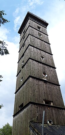
B tower
A B tower was a tower in the directional radio network of the SED and other state organs of the GDR .
B tower in the directional radio network of the SED (relay point for radio link connections)
So-called B towers were used in the SED directional radio network as a relay point between the A towers and the users' directional radio terminals. B towers were standardized reuse projects with a height of 25 m and a base area of 4 m × 4 m. The B towers were built in the late 1950s as part of the construction of the SED directional radio network on behalf of Fundament GmbH, the construction company of the SED. A total of 23 identical towers were erected in the GDR territory, of which twelve still existed in 2019. In the towers there were two emergency power systems as well as extensive air conditioning technology for cooling the tube-equipped transmitter systems.
Location of the built B towers
| 1 | 01B2 | Gresenhorst | 12 ° 26 '47.35 "East, 54 ° 08' 43.38" North | 50 m |
| 2 | 02B2 | Klein Upahl | 12 ° 04 '01.88 "East, 53 ° 42' 39.55" North | 87 m |
| 3 | 03B2 | New Falkenhagen | 12 ° 41 '25.68 "East, 53 ° 32' 53.45" North | 91 m |
| 4th | 04B2 | Rabenstein , old 0441 | 12 ° 34 '58.50 "East, 52 ° 02' 02.95" North | 150 m |
| 5 | 04B3 | New Vehlefanz | 13 ° 02 '29.89 "East, 52 ° 41' 45.80" North | 65 m |
| 6th | 05B2 | Rose garden, old 0541 | 14 ° 29 '21.01 "East, 52 ° 20' 08.19" North | 105 m |
| 7th | 06B2 | Schönheide | 14 ° 30 '41.73 "East, 51 ° 34' 06.09" North | 157 m |
| 8th | 08B2 | Blankenheim | 11 ° 24 '35.94 "East, 51 ° 31' 05.47" North | 325 m |
| 9 | 08B3 | Sandersleben | 11 ° 34 '39.17 "East, 51 ° 41' 15.74" North | 184 m |
| 10 | 09B2 | Kallmerode | 10 ° 16 '49.99 "East, 51 ° 20' 53.27" North | 507 m |
| 11 | 09B3 | Sondershausen | 10 ° 49 '54.22 "East, 51 ° 22' 38.31" North | 385 m |
| 12 | 10B3 | Gera , old 0941 | 12 ° 04 '33.65 "East, 50 ° 55' 06.73" North | 286 m |
| 13 | 10B2 | Jena | 11 ° 33 '56.42 "East, 50 ° 52' 50.55" North | 391 m |
| 14th | - | Suhl- Erleshügel, old 1041 | 10 ° 44 '43.57 "East, 50 ° 36' 46.62" North | 823 m |
| 15th | 11B2 | Kickelhahn | 10 ° 52 '55.57 "East, 50 ° 39' 53.35" North | 858 m |
| 16 | 11B3 | Bleßberg | 11 ° 00 '21.18 "East, 50 ° 26' 45.45" North | 862 m |
| 17th | 12B2 | Rotstein | 14 ° 45 '17.74 "East, 51 ° 06' 43.19" North | 401 m |
| 18th | 12B3 | Polenz | 13 ° 26 '59.73 "East, 51 ° 07' 26.11" North | 262 m |
| 19th | 12B4 | Neustadt / Sa. | 14 ° 13 '31.78 "East, 50 ° 59' 47.78" North | 528 m |
| 20th | 14B2 | Marienberg | 13 ° 07 '30.26 "East, 50 ° 39' 24.35" North | 684 m |
| 21st | 14B5 | Grünhain | 12 ° 47 '23.91 "East, 50 ° 34' 34.10" North | 719 m |
| 22nd | 14B3 | Mühlleiten / Kiel | 12 ° 28 '08.26 "East, 50 ° 24' 24.63" North | 942 m |
| 23 | 14B4 | Who's there | 12 ° 17 '39.51 "East, 50 ° 25' 36.22" North | 666 m |
