B6 (Cyprus)
| Main street 6 in Cyprus | |
| map | |
| Basic data | |
| Operator: | |
| Start of the street: | Limassol |
| End of street: | Paphos |
| Overall length: | 60 km |
|
( District ): |
|
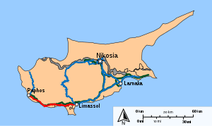
The B6 is a first order main road in Cyprus . It connects the city of Limassol with the city of Paphos over a distance of about 60 km.
course

The B6 begins in the urban area of Limassol and runs from here to the west directly on the border with the British military area Akrotiri . Shortly before the Kourion archaeological site , the road enters the military area. It then crosses the administrative headquarters of the two British military bases on Cyprus ( Episkopi Cantonment ) and the town of Paramali , before returning to Cypriot territory at Avdimou . After the town of Pissouri , the B6 meets the south coast of the island , where it passes directly by Petra tou Romiou , a striking rock on the beach and the place where the Greek goddess Aphrodite is said to have landed for the first time according to Greek mythology . That is why this section of the road is particularly popular with tourists. The road then follows the coastline and the A6 , past the town of Kouklia and Paphos airport and through the towns of Timi , Acheleia , Koloni and Geroskipou . Then it reaches the urban area of Paphos and ends in the old town of Paphos on the B20 and B7 .


