Babahoyo
| Babahoyo | ||
|---|---|---|
|
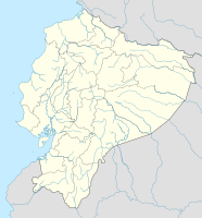
Coordinates: 1 ° 48 ′ S , 79 ° 31 ′ W Babahoyo on the map of Ecuador
|
||
| Basic data | ||
| Country | Ecuador | |
| province | Los Ríos | |
| City foundation | 1756 | |
| Residents | 140,534 (Ber. 2010) | |
| City insignia | ||
| Detailed data | ||
| surface | 174.58 km 2 | |
| Population density | 805 inhabitants / km 2 | |
| height | 8 m | |
| Waters | Río Babahoyo , Río Catarama , Río San Pablo | |
| Time zone | UTC -5 | |
| City Presidency | Johnny Teran | |
| Website | ||
Babahoyo is the capital of the Ecuadorian province of Los Ríos , capital of the canton Babahoyo and, according to the census, had 76,869 inhabitants in 2001 , the population in 2005 was estimated at 84,421.
The city is surrounded by the two rivers Río San Pablo and Río Catarama , which form the Río Babahoyo near the city , which flows further south into the Río Guayas . Babahoyo is located on one of the most important connecting routes in the country, the most traveled route from Guayaquil to Quito .
Most of the population lives from agriculture ( mainly bananas , cocoa , rice , sugar cane and fruit ). Some of the largest banana plantations are in the Babahoyo area.
The city is the seat of the Roman Catholic Diocese of Babahoyo .
Web links
Commons : Babahoyo - collection of pictures, videos and audio files


