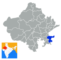
Baran (District)
| Baran District | |
|---|---|

|
|
| State | Rajasthan |
| Administrative headquarters : | Baran |
| Area : | 6992 km² |
| Residents : | 1,222,755 (2011) |
| Population density : | 175 inhabitants / km² |
| Website : | http://baran.rajasthan.gov.in |
Baran is a district in the Indian state of Rajasthan .
The district was created on April 10, 1991 by splitting off from the Kota district . It is located in the far east of Rajasthan. Much of the area was part of the princely state of Kota before Indian independence in 1947 . The district administration is located in the eponymous city of Baran . Major rivers in the district are Parbati and Kali Sindh .
population
The population was 1,222,755 in the 2011 census, 10 years earlier it was 1,021,653. The gender ratio was 929 women for 1,000 men. The literacy rate was 66.66% (80.35% for men, 51.96% for women). 92.69% of the population were followers of Hinduism , 6.54% Muslim . The main dialect is Hadoti .
Administrative division
The district is divided into 8 tehsils :
Cities with the status of a municipality are:
