Barentons
|
Barentons Ru of the barentons |
||
|
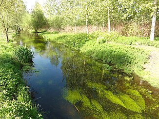
The river in Barenton-Bugny |
||
| Data | ||
| Water code | FR : H0160600 | |
| location | France , Hauts-de-France region | |
| River system | His | |
| Drain over | Souche → Serre → Oise → Seine → English Channel | |
| source | in the municipality of Festieux 49 ° 30 '57 " N , 3 ° 45' 25" O |
|
| Source height | approx. 129 m | |
| muzzle | in the municipality of Barenton-sur-Serre in the Souche Coordinates: 49 ° 40 ′ 24 ″ N , 3 ° 41 ′ 3 ″ E 49 ° 40 ′ 24 ″ N , 3 ° 41 ′ 3 ″ E |
|
| Mouth height | approx. 63 m | |
| Height difference | approx. 66 m | |
| Bottom slope | approx. 2.6 ‰ | |
| length | approx. 25 km | |
| Medium-sized cities | Laon | |
Barentons ( pluraletantum ) is a river in France , in the Aisne department in the Hauts-de-France region .
course
It rises in the southern municipal area of Festieux , drains in an arc from northwest to northeast and after around 25 kilometers flows into the Souche as a left tributary in the municipality of Barenton-sur-Serre . In its central section, it briefly touches the municipal boundary of the city of Laon , near the Laon-Chambry airport , and passes under the A26 motorway .
Places on the river
(Order in flow direction)
- Festieux
- Eppes
- Athies-sous-Laon
- Chambry
- Barenton Bugny
- Barenton cel
- Verneuil-sur-Serre
- Barenton-sur-Serre
ecology
The river runs through a number of small wetlands , which are combined in the lower reaches of the Vallée des Barentons nature reserve .
Web links
Commons : Barentons - collection of images, videos and audio files
