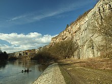
Barrandium


The Barrandium ( Czech Barrandium ), together with the geological units upstream to the north, is part of the Teplá-Barrandium , a geological area unit in the Czech Republic that extends between Brandys nL in the northeast via Prague to Pilsen in the southwest. The central part with the Silurian and Devonian sedimentary structures, which stretches between Suchomasty and Prague, is often viewed as the Barrandium alone, as it is the focus of attention because of its geoscientific and cultural history of exploration. Around 1900 this area was still called the Central Bohemian Limestone Plateau .
history
It was named after the French geologist, paleontologist and engineer Joachim Barrande (1799-1883). He called the region the Système silurien du center de la Bohême . The rich occurrence of fossils attracted the interest of geologists as early as the 18th century. From the localities that are now under nature protection such as quarries, road cuts or natural outcrops such as B. Streams were collected from Barrande rich ancient fauna . The following should be emphasized: Trilobites , brachiopods , graptolites , nautiloids , crinoids . Parts of Barrande's collection are in the National Museum in Prague .
Barrandium
The area, also known as Prague Basin (pražské pánvi) and Prager trough is referred to, rocks comprising Paleozoic . It is known to geologists and paleontologists mainly because of the widespread and easy-to-study sedimentary rocks from the Cambrian , Ordovician , Silurian and Devonian . The system boundary between the Silurian and Devonian in the profile at Klonk or the lower to middle Devonian reef complex at Koněprusy should be emphasized . Another important outcrop is in the valley between Velká Chuchle and Slivenec, which here also represents the transition between Silurian and Devonian and is equipped with an inscribed bronze plaque. The rocks of the area were folded during the Variscan mountain formation , pushed together by thrusts and partially transformed by metamorphosis .
Teplá barrandium
Together with the Barrandium form the north and northwest upstream rocks of Proterozoic the varisizische unit of the Teplá-Barrandian, a subunit of the Bohemikums in Czech solid . The Teplá - Blovice group and the Davle - Jílové group (combined in the southern part of the Barrandian to form the Kralupy - Zbraslav group), named after the localities near the characteristic units, form the sub-stock of the Paleozoic rocks of the Barrandian. In earlier geological literature they were referred to as the Pre-Spilitic Group (Teplá-Blovice Group) and the Spilitic Group (Davle-Jilové Group). In addition to the characteristic spilites and keratophyres, they consist of a mighty series of greywacke , siltstone and clay schist that have been transformed into phyllite , mica schist and paragneiss . The sequence of the Proterozoic is completed by the Young Precambrian flysch succession of the Štěchovice group ( Postspilitische Gruppe ). At the end of the Precambrian, the rocks previously deposited were folded and deformed during the Cadomian orogeny . After the mountain formation, erosion and profound weathering took place before the Barrandian developed.
literature
- Ivo Chlupáč et al .: Geologická minulost České Republiky . 1st edition. Academia, Praha 2002, ISBN 80-200-0914-0 .
- Friedrich Katzer: Geology of Bohemia . 2nd Edition. I. Taussig, Prague 1902.
- Reinhard Schönenberg, Joachim Neugebauer: Introduction to the geology of Europe . 4th edition. Verlag Rombach, Freiburg 1981, ISBN 3-7930-0914-9 , p. 90 f .
- Josef Svoboda, Ferdinand Prantl: Barrandium. Geology of the Central Bohemian Silurian and Devonian in pictures . 1st edition. Ùstřední Ùstav Geologický, Prague 1958.
- Roland Walter et al .: Geology of Central Europe . 5th edition. Schweizerbarth'sche Verlagsbuchhandlung, Stuttgart 1992, ISBN 3-510-65149-9 , pp. 300 f .
Individual evidence
Coordinates: 49 ° 48 ′ 0 ″ N , 13 ° 58 ′ 20 ″ E
