Behedan
| Behedan | ||
|---|---|---|
|
|
||
| Coordinates | 8 ° 30 ′ S , 125 ° 57 ′ E | |
 The Manatuto community The Manatuto community
|
||
| Basic data | ||
| Country | East Timor | |
| Manatuto | ||
| Administrative office | Laclo | |
| ISO 3166-2 | TL-MT | |
| Suco | Uma Caduac | |
| height | 35 m | |
|
Behedan's main street
|
||
Behedan (Beheda) is an East Timorese settlement in Suco Uma Caduac ( Laclo administrative office , Manaturo municipality ).
geography
Behedan is on the road that runs along the north coast of Timor and connects the state capital Dili with the east of the country, but here runs a little further inland. To the east is the municipality capital Manatuto , to the west the village of Subau . The hills on the coast rise rapidly, the top of which, south of Subau and Behedan, forms the isolated Curi at 1332 m . Behedan is part of the Important Bird Area , the center of which is the Curi.
Residents
The original language of the region is Dadu'a. It is a dialect of Wetar that emigrants brought from the island of Atauro to Ili-Mano and Behedan and is now spoken here by their descendants.
Infrastructure
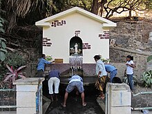
The place is known for the Antonius spring in the town center, which carries plenty of water even in the dry season. Intercity buses that run on the route often use them for a stopover. There is also a primary school in Behedan.
economy
There are limestone and marble deposits near Behedan which would be economically viable to mine. However, this is seen as a threat to nature.
Web links
Individual evidence
- ^ Timor-Leste GIS-Portal ( Memento from June 30, 2007 in the Internet Archive )
- ↑ a b Birdlife International IBAs in Timor-Leste ( Memento from November 22, 2008 in the Internet Archive ) (PDF; 2.0 MB)
- ^ Geoffrey Hull : The Languages of East Timor. Some Basic Facts , Instituto Nacional de Linguística, Universidade Nacional de Timor Lorosa'e ( Memento of the original from May 8, 2016 in the Internet Archive ) Info: The archive link has been inserted automatically and has not yet been checked. Please check the original and archive link according to the instructions and then remove this notice. (PDF file; 203 kB)
- ↑ UNMIT map of the Manatuto district, August 2008 ( Memento of December 3, 2011 in the Internet Archive ) (PDF; 581 kB)
- ↑ Jorge Manuel Ferreira Carvalho, José Vítor Vieira Lisboa: Calcários ornamentais de Beheda (Timor Leste) , accessed on December 10, 2016 (with a geological map of the region).
- ^ Helio da Costa Cristovão: Cartografia e estrutura dos calcários ornamentais da região de Beheda. Implicações para a exploração , 2011 , accessed December 10, 2016.


