Bergerfurth
|
Bergerfurth
City of Wesel
Coordinates: 51 ° 42 ′ 55 ″ N , 6 ° 31 ′ 2 ″ E
|
|
|---|---|
| Height : | 25 m above sea level NN |
| Area : | 2.38 km² |
| Residents : | 125 (Dec. 31, 2019) |
| Population density : | 53 inhabitants / km² |
| Postal code : | 46487 |
| Area code : | 02859 |
|
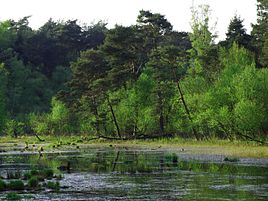
Moor in the forest near Bergerfurth
|
|
Bergerfurth is a district of the Hanseatic city of Wesel on the Lower Rhine . It is located on the northwestern edge of the urban area, belongs to the Bislich district and has 125 inhabitants (as of 2019).
geography
Bergerfurth is far from Wesel city center between a larger forest area east / southeast of the town and several the western lakes . The federal road 8 (under the name Landesstraße 7) leads through the small village, which leaves the Wesel urban area in the direction of Mehrhoog (city of Hamminkeln ) directly north of the town exit . Other neighboring towns are Hamminkeln in the west, Diersfordt in the south and Bislich in the south-west. There are also a number of quarry ponds between Bergerfurth, Bislich and Diersfordt, including the Diersfordter Waldsee . Bergerfurth is connected to the bus network by line 63. This stops in the village and leads in one direction via Diersfordt and Flüren to Wesel, in the other direction via Mehrhoog to Empel bei Rees.
History and Development
In the late Middle Ages, there was a kind of small castle or manor to the west of today's town, which was first mentioned in 1364. Historical names of the place have been preserved through the mentions of the building: Bargervoert (1364), Bergervuyrtt (1482), Bergerfuyrt (1510). It was administered earlier as part of the Bislich parish, from which the Bislich community later emerged. In 1868 a chapel was built in Bergerfurth, which was named St. Aloysius after Aloisius von Gonzaga . It was expanded in 1897 and received the status of a rectorate church in 1898, but was not an independent parish church.
The landscape around the place changed from the second half of the 20th century onwards through the gravel dredging and the creation of quarry ponds. In 2015, a land use plan was decided to simplify the use of the water areas and promote leisure and tourism.
Individual evidence
- ↑ https://www.wesel.de/politik-verwaltung/stadtverwaltung/statistik/bevolkerungszahlen
- ↑ https://www.geoportal-wesel.de//kat5/?es=C1
- ↑ State castles, fortresses, palaces and permanent houses up to 1500 in the mirror of the written documents
- ↑ http://www.eugen-perau.de/orte/bislich.html
- ^ Börsting, H .: History of the Diocese of Münster (1951)
- ↑ http://www.bislich.de/content/nun-k%C3%B6nnen-die-hausboote-kommen

