Bettmerhorn
| Bettmerhorn | ||
|---|---|---|
|
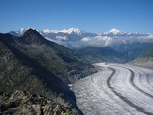
Bettmerhorn above the Aletsch Glacier |
||
| height | 2857 m above sea level M. | |
| location | Canton of Valais , Switzerland | |
| Mountains | Bernese Alps | |
| Dominance | 1.2 km → Fiescherhorli | |
| Notch height | 150 m ↓ Elselicka | |
| Coordinates | 649 313 / 140 517 | |
|
|
||
| rock | Aargranite | |
The Bettmerhorn is 2857 m above sea level. M. high summit in the Bernese Alps in the Swiss canton of Valais .
Location and geology
The Bettmerhorn is located at the southern end of the Bettmergrat , which runs from the main summit of the area, the Eggishorn , to the south-southwest and is accordingly a rather inconspicuous summit when viewed from the northeast. The ridge, the highest point of which measures 2,871 m , slopes down to the Aletsch Glacier in the west and to Bettmeralp and the Rhone Valley in the east . Geologically, it belongs to the metamorphic shell of the granitic Aar massif and consists of gneiss and mica schist . Due to the deep weathering , the rock on the surface is very fragmented as a huge rubble mountain, inside it is held together by permafrost .
The access to a train justifies the panorama of the Aletsch Glacier and the access to a ski area in winter. You can see many well-known mountains such as Monte Leone , Monte Rosa , Matterhorn , Weisshorn , Mont Blanc , Aletschhorn as well as the tongue area and the lower part of the Aletsch Glacier .
Cable car and hikes
The Bettmerhorn can be reached with a cable car from Bettmeralp. It reaches a height of 2647 m on the south side of the summit. A hiking trail with wooden stairs leads from the station to the actual summit in around 20 minutes. From the summit, the UNESCO high-altitude trail created in 2004 leads experienced mountain hikers (sure-footedness and a head for heights required) over the ridge to Eggishorn . For walkers it is possible to see the Aletsch Glacier along the western flank of the summit. The viewing terrace and the way to it are wheelchair accessible. There is a multimedia exhibition on the Aletsch Glacier in the mountain station. It takes 5 hours to walk around the entire mountain (Bettmerhorn and Eggishorn) from the mountain station, with a slight downhill walk of around four and a half kilometers along the Aletsch glacier to Lake Märjelensee . From there the path leads around the Tällerat back towards Fiescheralp and Bettmeralp.
The Bettmerhorn is located in the area of the Jungfrau-Aletsch-Bietschhorn mountain region, which was declared a UNESCO World Heritage Site in 2002 .
Web links
- Bettmerhorn on the ETHorama platform
- Bettmerhorn mountain railways
- MySwitzerland hiking suggestions
- WeatherCam live image


