
Jerusalem District
| Jerusalem District | |
|---|---|
 _(semi-Israel_areas_hatched).svg) |
|
| Basic data | |
| Country | Israel |
| Capital | Jerusalem |
| surface | 653 km² |
| Residents | 1,083,300 |
| density | 1659 inhabitants per km² |
| ISO 3166-2 | IL-JM |
Coordinates: 31 ° 48 ' N , 35 ° 0' E
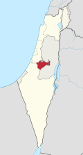
The Jerusalem District ( Hebrew מחוז ירושלים) is one of the six districts in the State of Israel . Its area is 653 km² (including East Jerusalem, which was annexed in 1980 ). It has 1,083,300 inhabitants.
The Jerusalem district is not divided into any further sub-districts.
Municipalities

City administrations
- Jerusalem ירושלים
- Bet Schemesch בית שמש
Local government
- Abu Gosh אבו גוש
- Mewasseret Zion מבשרת ציון
- Kirjat Je'arim קריית יערים
Regional administration
Residents
Population 2005: 68% Jews, 28% Muslim Arabs, 2% Christian Arabs
Population development
| year | population |
|---|---|
| 1983 census | 472,900 |
| 1995 census | 682,500 |
| 2008 census | 904.100 |
| 2016 estimate | 1,083,300 |
See also
Web links
Commons : Jerusalem District - Collection of images, videos and audio files
Individual evidence
- ↑ Israel in Figures 2006 ( Memento of the original from September 23, 2015 in the Internet Archive ) Info: The archive link was inserted automatically and has not yet been checked. Please check the original and archive link according to the instructions and then remove this notice. (PDF) Israel Central Bureau of Statistics
- ^ Israel: Districts, Cities & Agglomerations - Population Statistics, Maps, Graphics, Weather and Web Information. Retrieved May 8, 2018 .