Bicol (river)
| Bicol | ||
|
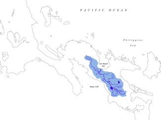
Catchment area of the Bicol |
||
| Data | ||
| location | on the island of Luzón | |
| River system | Bicol | |
| origin |
Lake Bato 13 ° 19 ′ 55 ″ N , 123 ° 21 ′ 32 ″ E |
|
| muzzle | to San Miguel Bay Coordinates: 13 ° 43 ′ 0 ″ N , 123 ° 6 ′ 25 ″ E 13 ° 43 ′ 0 ″ N , 123 ° 6 ′ 25 ″ E
|
|
| length | 136 km | |
| Catchment area | 3771 km² | |
| Big cities | Iriga City , Naga City | |
The Bicol River is a river in the Bicol District of the Philippines . It rises on Mount Mayon and flows into San Miguel Bay after about 136 km . Its catchment area is to the north, to the Philippine Sea , bounded by the volcanoes Mayon, Labo , Masaraga , Malinao and Isarog . To the south, its catchment area is separated from the Gulf of Ragay and the Burias Canal by a ridge .
It has a water catchment area of 3,771 km², which includes the Buhi , Bato and Baao lakes grouped around the Iriga volcano . The catchment area extends across the provinces of Albay , Camarines Sur and smaller parts of Camarines Norte . There are also 38 municipalities and three larger cities in its basin. Its main tributaries are the Quinali, Talisay, San Francisco, Naporong, Iriga, Pawili, and the Sipocot-Libmanan Rivers. The water runoff is around 5,100 million m³ per year.
Web links
- Bicol river on Wikipflipinas

