Bongolava
| Bongolava | |
|---|---|
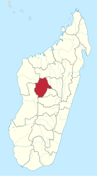
 Bongolava (red) is located in the center of Madagascar |
|
| Basic data | |
| Country | Madagascar |
| Capital | Tsiroanomandidy |
| surface | 17,983 km² |
| Residents | 470,000 (2014) |
| density | 26 inhabitants per km² |
| founding | 2004 |
| ISO 3166-2 | MG |
Coordinates: 18 ° 46 ′ S , 46 ° 3 ′ E
Bongolava is one of 22 regions ( Faritra ) of Madagascar in the mid-west of the island. In 2014, around 470,000 people lived in the region. The 22 regions of Madagascar were founded in June 2004. On April 4, 2007, Marc Ravalomanana held a referendum on an amendment to the constitution, which established a new administrative structure without provinces from October 2009. The regions thus became the first administrative unit.
geography
Bongolava is located in the central highlands of Madagascar and has an area of 17,983 km², of which 88.9% are savannah-like (mainly covered with sweet grass ). 5.9% are covered with forests and 0.5% with water. The region forms the eastern part of the former province of Antananarivo and borders in the north on Betsiboka , in the east on Analamanga and Itasy , in the south on Vakinankaratra , in the west on Menabe and in the northwest on Melaky .
The Kiranomena , Mahajilo and Manambolo rivers flow through Bongolava.
Economy and Infrastructure
Despite the predominantly ferralitic soils, maize and cassava are grown.
At the end of October 2017 , 720 solar modules were put into operation by the United States Agency for International Development (USAID) as part of the Power Africa program at Belobaka , in the east of Bongolava . The 63 million US dollars expensive plant has 315 kWh storage capacity and can provide several communities for three days by battery power. The system is one of a total of 100 systems that are to be installed throughout Madagascar.
traffic
The national road 1 comes from the east of Antananarivo and joins the national road 1b at Tsiroanomandidy . The national road 1b runs from the south-east via Tsiroanomandidy to the north-west towards Maintirano .
Administrative division
The Bongolava region is divided into two districts ( Fivondronana ):
Web links
- Information about Bongolava on the website of the Ministère de l'Economie et du Plan (French)
Individual evidence
- ↑ Bongolava population statistics. citypopulation.de, November 17, 2015, accessed on November 12, 2017 (German).
- ↑ Diana. Ministère de l'Economie et du Plan, accessed on November 19, 2017 (French).
- ↑ a b c Bongolava. Ministère de l'Economie et du Plan, accessed on November 12, 2017 (French).
- ^ Frederic Brown: Madagascar commissions its first solar-plus-storage project. pv magazine, November 2, 2017, accessed November 12, 2017 .
