Mahajanga (Province)
| Mahajanga | |
|---|---|
 |
|
| Basic data | |
| Country | Madagascar |
| Capital | Mahajanga |
| surface | 150,023 km² |
| Residents | 1,733,917 (2001) |
| density | 12 inhabitants per km² |
| ISO 3166-2 | MG-M |
Coordinates: 16 ° 45 ′ S , 46 ° 15 ′ E
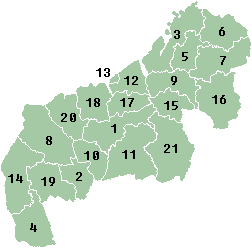
Mahajanga is a former province ( faritany mizakatena ) of Madagascar with the capital Mahajanga . It is located in the northwest of the country, had an area of 150,023 km² and around 1.73 million inhabitants. On April 4, 2007, Marc Ravalomanana held a referendum on an amendment to the constitution, which established a new administrative structure without provinces from October 2009.
geography
With the exception of Fianarantsoa , Mahajanga bordered on all other provinces of Madagascar. Antsiranana in the north, Toamasina in the east, Antananarivo in the southeast and Toliara in the south. Mahajanga bordered the Mozambique Strait to the west .
Breakdown
Until October 2009 Madagascar was divided into six provinces ( faritany mizakatena ). The regions ( Faritra ) founded in 2004 were the second administrative unit until the provinces were dissolved. From November 2009 they became the first administrative unit. The regions are each divided into districts ( Fivondronana ). The breakdown for the former Mahajanga Province is shown below.
|
|
Web links
Individual evidence
- ↑ Administrative units - Madagascar ( Memento of December 21, 2008 in the Internet Archive )
- ↑ Diana. Ministère de l'Economie et du Plan, accessed on November 19, 2017 (French).

