
Brümmerhof (Zeven)
|
Brümmerhof
Brümmerhoff ( Low German ) City of Zeven
|
||
|---|---|---|
 |
||
| Height : | 25 m above sea level NHN | |
| Area : | 3.82 km² | |
| Residents : | 74 (Jun. 30, 2016) | |
| Population density : | 19 inhabitants / km² | |
| Incorporation : | March 1, 1974 | |
| Postal code : | 27404 | |
| Area code : | 04281 | |
Location of Brümmerhof in Lower Saxony |
||
 Place name sign of Brümmerhof
|
||

Brümmerhof ( Low German Brümmerhoff ) is a district of the town of Zeven in Lower Saxony Rotenburg (Wümme) .
geography
Brümmerhof is located south of the core town of Zeven on Landesstrasse 132. The Mehde-Aue , a left tributary of the Oste, flows to the east . The B 71 also runs to the east .
history
Brümmerhof belonged to the parish of Heeslingen until 1141. With the relocation of the monastery from Heeslingen to Zeven, the place became part of the newly founded parish of Zeven. During the Middle Ages, most of the courtyards became dependent on the monastery in Zeven. In Brümmerhof there were two courtyards around 1500, which were still referred to as half courtyards after 1700, which is taken as an indication that the original courtyard was already divided before 1500.
As part of the regional reform in Lower Saxony , the previously independent municipality of Brümmerhof was incorporated into Zeven on March 1, 1974. On June 30, 2016, 74 people lived in Brümmerhof.
gallery

Cenotaph in Brümmerhof
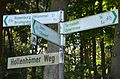
Signs of the cycle paths and distances in Brümmerhof


Web links
Individual evidence
- ↑ Lower Saxony State Administration Office (ed.): Municipal directory for Lower Saxony . Municipalities and municipality-free areas. Self-published, Hanover January 1, 1973, p. 43 , Bremervörde district ( digitized version ( memento from August 7, 2019 in the Internet Archive ) [PDF; 21.3 MB ; accessed on May 25, 2020]).
- ↑ a b Samtgemeinde Zeven (Ed.): Block statistics. Age group statistics City of Zeven . Evaluation area Brümmerhof. June 30, 2016.
- ↑ Ewald and Hermine Albers: The villages of the parish of Zeven. From the history of the farms and their families . Ed .: Heimatbund Bremervörde-Zeven e. V. Zeven 2002, p. 9 .
- ↑ Ewald and Hermine Albers: The villages of the parish of Zeven. From the history of the farms and their families . Ed .: Heimatbund Bremervörde-Zeven e. V. Zeven 2002, p. 85 .
- ^ Federal Statistical Office (ed.): Historical municipality directory for the Federal Republic of Germany. Name, border and key number changes in municipalities, counties and administrative districts from May 27, 1970 to December 31, 1982 . W. Kohlhammer, Stuttgart / Mainz 1983, ISBN 3-17-003263-1 , p. 241 .

Aspe | Bath chairs | Badenstedt | Brauel | Brümmerhof | Brüttendorf | Oldendorf | Wistedt | Zeven (core town)