
Eisbründlhöhle
| Eisbründlhöhle
|
||
|---|---|---|
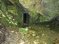
 Cave entrance after a rainfall event |
||
| Location: | Buchkogel , Graz , Styria | |
| Height : | 372 m above sea level A. | |
|
Geographic location: |
47 ° 2 '31 " N , 15 ° 22' 51" E | |
|
||
| Cadastral number: | 2793/1 | |
| Type: | Karst cave | |
| Overall length: | unknown | |
| Level difference: | ~ 180 m (including connection with Feliferhof cave) | |
| Particularities: | Source of the Bründlbach | |

The Eisbründlhöhle or Bründlhöhle is a karst cave in the Straßgang district of the Styrian capital Graz . The episodic water-bearing Bründlbach rises from the cave . The nearby Bründl ponds not far from the St. Martin Castle form a popular local recreation area .
Location and geology
The cave is located at the eastern foot of the Buchkogel a good 5 km outside of Graz city center in the Straßgang district. From the next bus stop of the Graz Linien (line 33) it takes about 10 minutes to walk.
Typical of the geological structure of the Plabutsch, the cavity is a karst phenomenon . It lies in an interposition of Eggenberger breccia in dolomite . In the course of hydrogeological investigations in the 1950s, underground connections with the Feliferhof Polje on the other side of the mountain were found, through which the spring of the Bründlbach, located inside the cave, is fed. Due to the characteristic of Karst systems bed equalization (including through precipitation dependence ), the water flows only episodic. In 1953, the average spring discharge was estimated at 4 to 6 l / s. The maximum value measured so far dates from 1956 and is 197 l / s.
The usable area of the cave was greatly reduced by falls and flooding. In the past, you could follow the stream to a small standing water called “dwarf paradise”, from the middle of which a prominent rock, the “Wichtelburg”, rose up. Today only a short, about 10 m long side corridor is accessible. After heavy rainfall, this part of the cave is filled with water, which makes wearing rubber boots indispensable.
history
The Eisbründlhöhle has already found its way into popular stories several times. A legend handed down by K. Haiding reads as follows:
“The entrance to an underground cave is said to be located near the Bründlteich near St. Martin. Maybe it's the entrance to the cave from which the brook comes. Through this passage one reaches a lake with unspeakable efforts and dangers, whose floods undermine the floor of the passage. If someone is so unhappy to reach this lake, Graz is lost, because the city is soon flooded by the waves of the lake. "
The name Bründl goes back to the Martinsbrunnen, a former spring whose water was said to have healing properties until the end of the 19th century. This fountain, which has now dried up, formed the heart of a spacious park with three ponds belonging to St. Martin Castle, which was even visited by Emperor Franz and his entourage in 1830. In an illustrated hiking guide from 1885, the park was described as follows:
“After the ponds, after a few steps we reach the grotto (the Eisbründl cave, note) and the little fountain in deep shadow, surrounded by an amphitheater made of lawn steps; a place so cozy that we like to dream away for an hour here. "
In the immediate vicinity of the cave entrance there is a quarry that has now been disused and, since 1987, the southern emergency exit of the Plabutsch tunnel .
The Bründlteiche
The three Bründl ponds were created as fish ponds in the 19th century and are fed by spring water from the interior of the cave. Today, as an important biotope , they form a protected part of the landscape . In addition to fish and mussels, there are numerous amphibian species, the vegetation in the vicinity is determined by an alder forest . The local recreational character of the 19th century has been preserved to this day, so a barrier-free hiking trail leads around the uppermost (largest) pond , and an educational forest trail can be followed in the direction of St. Martin .
Flood protection
In the past, flood damage occurred repeatedly in the Bründlwiese area and on the former premises of Leykam Medien AG . For this reason, a retention basin was built for the Bründlbach in 2011 and 2012 .
photos
Cave entrance
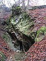
Cave entrance in the dolomite

Upper Bründlteich


literature
- Annemarie Reiter: The Plabutsch. The highest mountain in Graz . Verlag für Collectors, Graz 1994, p. 16 u. 60-63, ISBN 3-85365-122-4 .
Web links
Individual evidence
- ^ Josef Zötl: The hydrogeological conditions in the area of the Buchkogelzug near Graz . In: Contributions to a hydrogeology of Styria, Heft 6, Graz 1953, pp. 24–32, ISSN 1012-0882 [1] , accessed on August 19, 2014
- ↑ Helmut Flügel: Die Geologie des Grazer Bergland , p. 233 Archived copy ( memento of the original from February 1, 2015 in the Internet Archive ) Info: The archive link was inserted automatically and has not yet been checked. Please check the original and archive link according to the instructions and then remove this notice. (PDF; 37 MB), accessed January 30, 2015
- ↑ a b c Annemarie Reiter: The Plabutsch. The highest mountain in Graz . (see literature)
- ↑ GLT 1306 Bründlteiche. Steiermärkische Berg- und Naturwacht , accessed on February 21, 2016 .
- ↑ State of Styria: “Bründlbach” flood protection project archive link ( memento of the original from June 17, 2015 in the Internet Archive ) Info: The archive link was automatically inserted and not yet checked. Please check the original and archive link according to the instructions and then remove this notice. (PDF; 23.2 kB), accessed on June 16, 2015