Brandhorn (Steinernes Meer)
| Brandhorn | ||
|---|---|---|
|
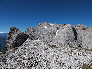
Kleines Brandhorn (left) and Brandhorn (center) from the east |
||
| height | 2610 m above sea level A. | |
| location | Salzburg , Austria | |
| Mountains | Steinernes Meer , Berchtesgaden Alps | |
| Dominance | 2.6 km → high wire rope | |
| Notch height | 187 m ↓ Wasserfallscharte | |
| Coordinates | 47 ° 26 ′ 51 ″ N , 13 ° 0 ′ 16 ″ E | |
|
|
||
| First ascent | Richard von Frey, Max von Frey , Richard Lonsky on September 11, 1875 | |
The Brandhorn is a 2610 m above sea level. A. high mountain in the Berchtesgaden Alps in the Austrian state of Salzburg . It is located in the southeast of the Steinerne Meer , at the transition to the Hochkönig . After Selbhorn ( 2655 m ) and Schönfeldspitze ( 2653 m ), the Brandhorn is the third highest peak in the Steinerne Meer.
Approaches
The connection path from the Riemannhaus to the Matrashaus - and thus the E4 alpin - leads over the Brandhorn. Difficulty level I – II , walking time 10–12 hours.
Further summit climbs:
- From the Eckberthütte via the Bohlensteig and Torcharte, I – II, partially secured, 4 hours
- From Steinhütterl over the Mauerscharte and the Alpriedelhorn, no path, 3½ hours
- From Hinterthal via Torcharte
literature
- Bernhard Kühnhauser: Alpine Club Guide Berchtesgaden Alps with Hochkönig . 20th edition. Bergverlag Rother , Munich 2011, ISBN 978-3-7633-1127-9 . Pp. 426-429, 568 f.
Individual evidence
- ↑ Richard von Frey: The Wildalm Church on the Stone Sea. In: Journal of the German and Austrian Alpine Club , year 1877, Volume 8, pp. 69–74 ( digitized version ).

