
Breccia Peak (Wyoming)
| Breccia Peak | ||
|---|---|---|
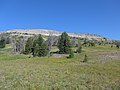
 Breccia Peak (center) from the southwest, from US Highway 26 / 287 northwest of Togwotee Pass . |
||
| height | 3356 m | |
| location | Teton County , Wyoming , USA | |
| Mountains | Southern Absaroka Range , Rocky Mountains | |
| Notch height | 60 m | |
| Coordinates | 43 ° 47 '16 " N , 110 ° 4' 29" W | |
|
||
| rock | Absaroka volcanic breccia | |

The Breccia Peak ( 3356 m ) is a mountain in the southern Absaroka Range in the Rocky Mountains . It is located in Teton County in the state of Wyoming not far from the Togwotee Pass and is on the southwestern edge of the Teton Wilderness , which is part of the Bridger-Teton National Forest .
Location and surroundings
Breccia Peak is a little more than four kilometers north of the Togwotee Pass , which connects the Jackson Hole valley in the west, through which the Snake River flows, with the valley of the Wind River in the east. The pass is part of the North American Continental Divide , the mountain is about seven kilometers west of this. To the west, the plateau-like summit area with the so-called Breccia Cliffs drops very steeply and rocky, and to the north it also shows steep walls. To the east and southeast, however, it shows a grassy flank, which, with the exception of the areas near the east and south-east ridge, is interrupted by a steep rock barrier at an altitude between 3200 and 3300 meters.
To the west of the mountain there are no higher mountains up to the Teton Range , which is more than 50 kilometers away . The Breccia Peak is not particularly independent, because to the higher Buffalo Fork Peak ( 3447 m ) to the north it only has a notch height of about 60 meters.
About two kilometers southwest of the Breccia Peaks is the Lost Lake at an altitude of about 2900 m , a small but scenic lake in which the Breccia Cliffs can be reflected.

geology
The rock in the area of the mountain is volcanic Absaroka breccia , which explains the name of the mountain. The rocks in the summit area belong to the Thorofare Creek Group of the Wiggins Formation , which can be assigned to the Upper Eocene . In the saddle between Breccia Peak and the north-west lying Angle Mountain ( 3237 m ) there is a long, irregular, intrusive rock body made of glassy, flow-banded rhyodacite porphyry , which shows only slight hydrothermal alteration .
Alpinism
Breccia Peak is one of the easiest mountains to climb in the Yellowstone region . From the starting point on Highway 26 / 287 approximately one kilometer north of Togwotee Pass it is about two hours on a relatively easy hike ( Class 2 in the Yosemite Decimal System or T3 in the SAC-scale hiking to reach). From the parking lot on the highway, a clearly recognizable path leads to the tree line and on to a large meadow southeast of the mountain. Right at the beginning the path forks, to Breccia Peak the left path has to be followed, the right one leads to Sublette Peak (Brooks Mountain).
You leave the hiking trail on the large meadow at an altitude of around 3050 m, where the south-eastern flank of the mountain is fully visible. The simplest option is to traverse the south-east flank without a path to the north in order to bypass the steep step in this flank at its right end, near the edge to the north. A little more difficult, but a little shorter, is the bypassing of this steep flank at its left, southwestern end. To do this, first turn west from the meadow to reach the summit further up, first in a north-westerly direction and later in a north-westerly direction.
In particular, the south-eastern flank of the mountain above the tree line is also suitable for ski tours in winter , but the runs are short, but many variants are possible.
The summit was in the total zone of the solar eclipse on August 21, 2017 and was dubbed one of the most special places in Wyoming's Wind River region to observe this eclipse.

Breccia Peak from the parking bay one kilometer north of the Togwotee Pass, in front of the beginning of the path.
Breccia Peak from the southeast on the ascent path, the rock barrier in the center of the picture can be bypassed on the far right or left.
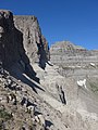
Northern edge of the Breccia Peak.

First notch between Breccia Peak and Buffalo Fork Peak, Mount Moran in the background.

View from Breccia Peak to the west, to the Teton Range , Lost Lake in the foreground.

Surveying point at the summit of the Breccia Peak.


Individual evidence
- ↑ Breccia Peak at listsofjohn.com, accessed on September 1, 2017
- ↑ a b c Breccia Peak at summitpost.org, accessed on September 1, 2017
- ↑ Bill Hunger: Hiking Wyoming: 110 Of The State's Best Hiking Adventures , 2nd Edition 2008, ISBN 978-1-4617-4576-1 , pp. 248-250.
- ↑ JC Antweiler, JD Love, Harold J. Prostka, Dolores M. Kulik, Lennart A. Anderson, Frank E. Williams, Jimmie E. Jinks, Thomas D. Light (US Geological Survey / US Bureau of Mines): Mineral Resources of the Teton Wilderness and Adjacent Areas, Teton, Fremont, and Park Counties, Wyoming. US Geological Survey Bulletin 1781, United States Government Printing Office, 1989 ( online ), Plate 1
- ↑ Breccia Peak Backcountry Skiing and Snowboarding at rootsrated.com
- ^ Wind River Visitors Council: Quirky Places to See the Total Solar Eclipse. Retrieved September 1, 2017
Web links
- Breccia Peak at summitpost.org