
Brunau (Örtze)
| Brunau | ||
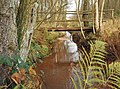
 Cutted pollard willows on the Brunau near Bonstorf |
||
| Data | ||
| location | Lower Saxony , Germany | |
| River system | Weser | |
| Drain over | Örtze → Aller → Weser → North Sea | |
| source | east of Nindorf 52 ° 50 ′ 29 ″ N , 9 ° 59 ′ 20 ″ E |
|
| Source height | 71 m above sea level NHN | |
| muzzle | North-east of Baven in the Örtze Coordinates: 52 ° 50 ′ 57 ″ N , 10 ° 6 ′ 6 ″ E 52 ° 50 ′ 57 ″ N , 10 ° 6 ′ 6 ″ E |
|
| Mouth height | 52 m above sea level NHN | |
| Height difference | 19 m | |
| Bottom slope | 1.8 ‰ | |
| length | 10.3 km | |
| Left tributaries | Süllbach | |
| Communities | Nindorf , Hetendorf , Bonstorf | |
The Brunau is a 10.3 km long stream in the district of Celle , in the Lüneburg Heath ( Germany ), a tributary of the Örtze .
Source and history
The Brunau rises near Nindorf (Bergen) and initially flows in a north-easterly direction to the south of Hetendorf . Here it swings to the east, past Bonstorf to the north and then continues in a south-easterly direction. The Brunau is dammed in the north of Baven. Originally a water mill was operated here. Here is the Backebergs-Mühle , formerly a water-powered grain mill. The Brunau flows directly under the building. Shortly before its mouth, the Brunau unites with an old, now disused and overgrown Rieselwiesen irrigation canal . It flows with this together at Baven north of Hermannsburg in the Örtze . Willows were planted on the edge of the river in the 1980s, mainly in the Bonstorf area . By regular pollarding are thus over the years Kopfweiden emerged. Numerous animals find shelter and nesting opportunities in the often hollow trunks.
Brunau southwest of Hetendorf

The Brunau at the Backebergs mill

Former lock to Örtze, from the right the Brunau, to the left the old Rieselwiesen irrigation canal


Water quality
The Brunau owes its name to its brown (Low German "bruun") water. The quality has, however, consistently grade II: moderately burdened
See also: Brunau (Luhe) , a body of water in the Heidekreis district that flows into the Luhe .
Web links
Individual evidence
- ↑ Celler Land and Upper Örtzetal , 2nd edition, KV Plan, 1: 60,000.
- ↑ Water quality map from NLWKN