Buchheller
| Buchheller | ||
|
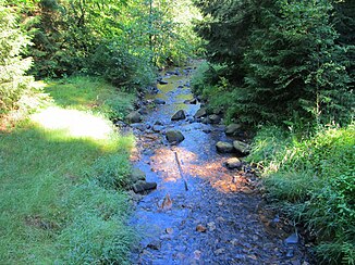
The Buchheller near the visitor parking lot |
||
| Data | ||
| Water code | DE : 272229 | |
| location | North Rhine-Westphalia , Germany | |
| River system | Rhine | |
| Drain over | Heller → Sieg → Rhine → North Sea | |
| source | Southwest of Lippe 50 ° 41 ′ 53 ″ N , 8 ° 2 ′ 21 ″ E |
|
| Source height | approx. 613 m above sea level NHN | |
| muzzle | East of Wahlbach Coordinates: 50 ° 45 '32 " N , 8 ° 3' 39" E 50 ° 45 '32 " N , 8 ° 3' 39" E |
|
| Mouth height | approx. 324 m above sea level NHN | |
| Height difference | approx. 289 m | |
| Bottom slope | approx. 32 ‰ | |
| length | 8.9 km | |
| Catchment area | 14.384 km² | |
| Reservoirs flowed through | Various former pit ponds | |
| Communities | Burbach | |
| Residents in the catchment area | approx. 2500 | |
The Buchheller is a southern and left tributary of the Heller in the local areas of Lippe , Burbach and Wahlbach in the municipality of Burbach in the southern Siegerland .
geography
course
The stream rises in the north of the Hohen Westerwald at the southeast foot of the footbridge at the junction of the districts of Emmerzhausen ( Altenkirchen district , Rhineland-Palatinate ), Stein-Neukirch ( Westerwaldkreis , RP) and Burbach ( North Rhine-Westphalia ). From now on it runs exclusively in the area of the last-mentioned municipality in northern directions through the place Lippe and from there to the southern Hellerbergland in the protected Upper Buchhellertal . The brook flows further into the Lower Buchhellertal between old mining heaps and pit ponds and finally between Burbach and Wahlbach into the Hellertal . There the stream flows a little further north into the Heller .
Catchment area and tributaries
The Buchheller catchment area is 14.384 km². Looking downstream, their tributaries include:
| Brook | page | length |
|---|---|---|
| inflow | Left | 0.51 km |
| inflow | right | 0.27 km |
| inflow | Left | 1.14 km |
| inflow | Left | 0.59 km |
| inflow | right | 0.63 km |
| Mathebach | Left | 1.02 km |
| inflow | right | 0.47 km |
| Dredenbach | Left | 1.38 km |
| inflow | Left | 0.33 km |
| inflow | Left | 0.71 km |
| inflow | right | 0.61 km |
mountains
The highest mountain near the stream is the Stegskopf at 654.4 m above sea level. NHN Höhe, the stream rises from it. Other mountains in the area are:
- Kühfelderstein , 637.6 m above sea level NHN , right
- Lipper Nürr , 616.9 m above sea level NHN , left
- Nenkersberg , 610.3 m above sea level NHN , left
- The castle , 594.5 m above sea level. NHN , right
- Schallroth, 446.3 m above sea level NHN , left
Buchhellertal
Mining
The Bleiberg mine was first mentioned in 1712 . Zinc and lead ores were mined. The Hoffnungsstern mine followed in 1720, where lead and silver ores were extracted from an artificial mine and in the mine. Around 1840, after a large copper find in Buchhellertal, numerous unions were formed. Well-known pits such as Mückenwiese , Frankenstein , Crone , Gabriel and Carlssegen formed. The later largest mine among them, the Peterszeche , was not founded until 1850, after a tunnel was excavated in the 1940s. In 1852 the first industrially operated mine in the valley was put into operation. On the Viktorsfeld mine , formerly Bleiberg , one of the first steam engines was installed for the mining of shafts in Siegerland. Operations ended here as early as 1862.
In 1865 the pits Hoffnungsstern , Viktorsfeld , Kupferkaute , Grüne Hope , Mückenwiese , Peterszeche and Crone were consolidated under the name Peterszeche . But the end of many pits was already in sight. 1867 was Crone closed in 1882 was followed by Green Hope , 1885 Hope Star . In 1917 work in the Peterszeche and the connected flotation plant was stopped. A stone crusher was in operation between 1922 and 1928, and in 1932 the last rails disappeared from the valley. Today in the Buchhellertal there are only the partially overgrown ruins of the stone crusher and isolated wall stumps in addition to the extensive spoil heaps of the pits.
- There were pits in the valley
|
|
|
|
Nature reserves
The Buchhellertal from the source to the mouth is divided into several nature reserves.
- NSG "Buchheller spring area" (203.3 ha)
- NSG "Hasseln" (24.7 ha - right, southeast of Lippe)
- NSG "Lipper Höhe" (16.3 ha - right, east of Lippe)
- NSG "Fuchsstein" (29.1 ha)
- NSG "Mückewies" (97.2 ha - left, west of NSG Hasseln)
- NSG "Oberes Buchhellertal" (18.4 ha)
- NSG "Unteres Buchhellertal" (33.6 ha)
Except for the NSG "Buchhellerquellgebiet", which is located on the Westerwald basalt plateau , all nature reserves are in the southern Hellerbergland .
At the beginning of the “Unteres Buchhellertal” nature reserve there is a parking lot, from which you can hike or cycle through the valley to Lippe. Until 2007 there was a restaurant in the valley itself on the hiking route.
Web links
Individual evidence
- ↑ a b German basic map 1: 5000
- ↑ a b c Topographical Information Management, Cologne District Government, Department GEObasis NRW
- ↑ Burbach landscape plan ( memento of the original from October 26, 2005 in the Internet Archive ) Info: The archive link was automatically inserted and not yet checked. Please check the original and archive link according to the instructions and then remove this notice. (December 18, 2003; PDF; 1.6 MB) on siegen-wittgenstein.de with all nature reserves


