
Castle moat (Attersee)
|
Burgbach moat , Magdalenenbach (upper course) |
||
|
|
||
| Data | ||
| Water code | AT : HZB: 2-122-152-29, Upper Austria: 500376, SBG: A3599177 | |
| Drain over | Attersee → Ager → Traun → Danube → Black Sea | |
| River basin district | Danube below Jochenstein | |
| source | on Schafberg 47 ° 46 '24 " N , 13 ° 28' 14" E |
|
| Source height | 1175 m above sea level A. | |
| muzzle | in Burgbachau Coordinates: 47 ° 47 '31 " N , 13 ° 29' 43" E 47 ° 47 '31 " N , 13 ° 29' 43" E |
|
| Mouth height | 469 m above sea level A. | |
| Height difference | 706 m | |
| Bottom slope | 18% | |
| length | 3.9 km | |
| Catchment area | 1.672 km² | |
| Left tributaries | Ditch | |
| Communities | St. Wolfgang , St. Gilgen , Unterach | |
| Burggrabenklamm natural monument | ||
The moat , older also Burgbach , on the upper reaches also Magdalenenbach , is a small brook in the Salzkammergut , which flows into the Attersee in the Lower Burgau belonging to the state of Salzburg .
Run and landscape
The stream rises at Feichtingeck ( 1412 m above sea level ), an eastern pre-summit of the Schafberg , west of the Moosalm in the Schwarzensee area , at about 1175 m above sea level. A. Height. This area is the municipality of Sankt Wolfgang . It then runs as a forest stream to the north end of the Moosalm, which is a valley watershed at 772 m above sea level. A. has. Then the stream falls steeply into the Ackergraben , in which the side stream from the Eisenaueralm flows. This upper course up to this point is also called Magdalenenbach . There is also the Magdalenenquelle , a healing spring established in 1893. Here the stream also passes the Upper Austria-Salzburg border and reaches the municipality of Sankt Gilgen .
A gorge follows , the Burggrabenklamm between Ackerschneid ( 1119 m above sea level ) to the west and Auberg ( 907 m above sea level ) to the east. At the end of this, the brook forms an alluvial cone into the Attersee, the Burgbachau . The lakeshore again forms the state border between Salzburg and Upper Austria, but the youngest gravelly estuary alluvial fan has pushed itself almost 20 meters above the old lakeshore line. The confluence is actually already in the municipality of Unterach .
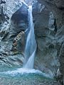
The waterfall up to which the gorge is accessible

The more inaccessible places

The gorge path at the gorge entrance


Individual evidence
- ↑ a b c d e f water book (online DORIS, topic water & geology and SAGIS, topic water ); ÖK - the name Magdalenenbach is given by the Hydrographic Central Office (catchment areas) ; the ÖK uses Burggraben as a field name for the Burggrabenklamm.
- ^ Alfred Mück: Unterach am Attersee. History of a Salzkammergut summer retreat. In: Yearbook of the municipal museum in Wels. 1936, Wels 1936. Chapter field names and place names. P. 147 (full article p. 29–155; second part (PDF) in the forum OoeGeschichte.at; there p. 80).