Carlshaushöhe
| Carlshaushöhe | ||
|---|---|---|
|
Carlshausturm |
||
| height | 626.3 m above sea level NHN | |
| location | District of Harz , Saxony-Anhalt ( Germany ) | |
| Mountains | resin | |
| Coordinates | 51 ° 39 '23 " N , 10 ° 47' 47" E | |
|
|
||
| rock | Greywacke | |
| particularities | 1901–1981 Bismarck tower since 1998 radio and observation tower |
|
The Carlshaushöhe (also called Karlshaushöhe ) in the Harz is 626.3 m above sea level. NHN high mountain in the urban area of Oberharz am Brocken in the Harz district , Saxony-Anhalt ( Germany ).
Geographical location
The Carlshaushöhe is located in the Lower Harz in the Harz / Saxony-Anhalt Nature Park . It rises southwest of Hasselfelde between Trautenstein in the north, Benneckenstein in the west and in Thuringia located Sophienhof (part of Harztor ) in the south.
Carlshausturm
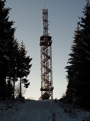
Near the mountain top stands - about 250 m southwest of the old forester's house Carlshaus (also called Karlshaus ; approx. 599 m ) - the Carlshausturm (also called Karlshausturm or Carlsturm ). It was built using open steel construction and was inaugurated on July 27, 1998. It is 50 m high.
The Carlshausturm serves as a radio tower for the Harz Narrow Gauge Railways (HSB), two sections of which lead past the tower a few kilometers to the south and east, and as a lookout tower .
From the viewing platform at about 30 m tower height , which can be reached via 155 steps and is located above the treetops, you can enjoy the all-round view, for example over the highlands of the Harz. You can see the Brocken , the Harz foreland and the Kyffhäuser , among other places .
Bismarck Tower
The Carlshausturm replaced the Bismarck tower Hasselfelde-Trautenstein , built in 1901 and demolished by the Soviet Army in 1981 , which was also made of open steel construction, was 20 m high and was crowned by a round viewing platform.
Transport links and hiking
The Carlshaushöhe rises between the federal roads 242 (in the north), 81 (east) and 4 (south-west) and the Harzquerbahn in the south and west. The mountain can be reached via hiking trails that lead past these streets or their side streets and lead to the Carlshausturm . The tower is included as no. 51 in the system of stamping points of the Harz hiking pin.
In winter, if there is enough snow, there is the Carlshaus Turm trail .
Individual evidence
- ↑ Map services of the Federal Agency for Nature Conservation ( information )
- ↑ a b c d e f Carlshausturm , on ausflugsziel-harz.de (see also the photo of the information board on the tower)
- ↑ Harzer Wanderadel: stamp point 51 / Carlsturm , on harzer-wandernadel.de

