Cartagena del Chairá
| Cartagena del Chairá | ||
|---|---|---|
|
Coordinates: 1 ° 20 ′ N , 74 ° 51 ′ W Cartagena del Chairá on the map of Colombia
|
||
|
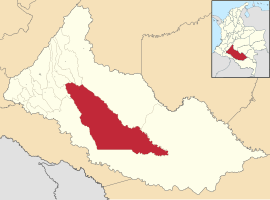
Location of the municipality of Cartagena del Chairá in Caquetá
|
||
| Basic data | ||
| Country | Colombia | |
| Department | Caquetá | |
| City foundation | 1966 | |
| Residents | 35,473 (2019) | |
| City insignia | ||
| Detailed data | ||
| surface | 12,826 km 2 | |
| Population density | 3 people / km 2 | |
| height | 350 m | |
| Waters | Río Caguán | |
| Time zone | UTC -5 | |
| City Presidency | Luis Francisco Vargas Correa (2016-2019) | |
| Website | ||
Cartagena del Chaira is a municipality ( municipio ) in the Colombian department of Caquetá .
geography
Cartagena del Chairá is located on the Río Caguán in Caquetá . The municipality is bordered to the north by Puerto Rico , El Doncello and El Paujil , to the northeast by San Vicente del Caguán , to the south, southeast and southwest by Solano and to the northwest by La Montañita .
population
The municipality of Cartagena del Chairá has 35,473 inhabitants, of whom 13,278 live in the urban part (cabecera municipal) of the municipality (as of 2019).
history
Cartagena del Chairá was founded in 1966. Cartagena del Chairá has had the status of a municipality since 1985. On the one hand, the name refers to the Colombian city of Cartagena de Indias , as the landscape in the region has some similarities with the fortress of San Felipe. The word Chairá comes from the Uitoto language and means tiger cave. The origins of non-indigenous settlement in the region go back to the rubber boom from 1890 onwards. Various multinational companies such as u. a. Shell carried out test wells in the region to look for oil in the first half of the 20th century, but left the region again without finding anything. From the late 1970s onwards, illegal coca cultivation and processing developed into a boom in the community, but this did not result in lasting wealth for the local farmers.
Web links
- Alcaldía Cartagena del Chairá. Alcaldía de Cartagena del Chairá - Caquetá, accessed on June 5, 2019 (Spanish, website of the municipality of Cartagena del Chairá).
Individual evidence
- ↑ ESTIMACIONES DE POBLACIÓN 1985 - 2005 Y PROYECCIONES DE POBLACIÓN 2005 - 2020 TOTAL DEPARTAMENTAL POR ÁREA. DANE, May 11, 2011, accessed on June 5, 2019 (Spanish, extrapolation of the population of Colombia (Excel; 1.72 MB)).
- ↑ Nuestro municipio. Alcaldía de Cartagena del Chairá - Caquetá, accessed on June 5, 2019 (Spanish, information about the municipality).


