Center (Alabama)
| Center | |
|---|---|
|
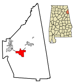
Located in Cherokee County and Alabama
|
|
| Basic data | |
| State : | United States |
| State : | Alabama |
| County : | Cherokee County |
| Coordinates : | 34 ° 10 ′ N , 85 ° 40 ′ W |
| Time zone : | Central ( UTC − 6 / −5 ) |
| Residents : | 3,489 (as of 2010) |
| Population density : | 117.9 inhabitants per km 2 |
| Area : | 29.9 km 2 (approx. 12 mi 2 ) of which 29.6 km 2 (approx. 11 mi 2 ) are land |
| Height : | 202 m |
| Postal code : | 35960 |
| Area code : | +1 256 |
| FIPS : | 01-13648 |
| GNIS ID : | 0115902 |
| Website : | www.cityofcentre.com |
Center is a city and county seat of Cherokee County in the state of Alabama in the United States . In 2010 Center had around 3500 inhabitants.
geography
Center is located in northeast Alabama in the southern United States. It is located directly on the 130 square kilometer Weiss Lake , which in turn is fed by the Coosa River . The city is about 17 kilometers west of the Georgia border .
Nearby locations include Leesburg (1 km west), Cedar Bluff (2 km north), Sand Rock (4 km northwest), Collinsville (11 km northwest), and Gaylesville (11 km northeast). The next larger city is Birmingham, about 105 kilometers southwest, with 212,000 inhabitants .
history
The Cherokee County was founded in 1835 after the Cherokee -Indianer had left the settlers of this. The first county seat was Turkeytown , later it became Cedar Bluff . In 1844 the county seat was moved to Center because of its central location, the name of which was also chosen because of its location. In 1865 a post office was established. The courthouse burned down completely in 1882 and 1895 and had to be rebuilt. The United States Postal Service ran the city as a center until 1939 .
The sale of alcohol was only allowed in Center in 2011, so the city has not been a dry city since then .
traffic
Alabama State Route 25 and US Highway 411 run through the city in a south-west direction , and Alabama State Route 9 and Alabama State Route 283 to the north . About 14 kilometers to the northwest there is a connection to US Highway 11 and 16 kilometers to the west of the connection to Interstate 59 .
To the east of the city is the Center Municipal Airport , 4 kilometers south of the Center – Piedmont – Cherokee County Regional Airport .
Demographics
The 2000 census showed a population of 3216, divided between 1324 households and 877 families. The population density was 113 people per square kilometer. 87.9% of the population were white, 10% black, 0.4% Native American and 0.1% Asian. 0.3% were of a different ethnicity , 1.3% had two or more ethnicities, and 1% were Hispanics or Latin Americans of any ethnicity. For every 100 women there were 81 men. The median age was 44 years and the per capita income was 14,997 US dollars, which put about 26.1% of the population below the poverty line.
By the 2010 census , the population rose to 3,489.
Web links
- Official website of the city (Engl.)
- Center in the Encyclopedia of Alabama (Engl.)
- Statistical data Center (Engl.)
Individual evidence
- ↑ Place Names in Alabama , University of Alabama Press, Tuscaloosa 1989, p. 30 ( on Google Books )
- ^ Explaining Centers New Alcoholic Beverages Ordinance , accessed July 7, 2015
- ↑ a b site of the United States Census Bureau , accessed on July 7, 2015
