
Champéry
| Champéry | |
|---|---|
 |
|
| State : |
|
| Canton : |
|
| District : | Monthey |
| BFS no. : | 6151 |
| Postal code : | 1874 |
| UN / LOCODE : | CH CHP |
| Coordinates : | 556 109 / 114225 |
| Height : | 1055 m above sea level M. |
| Height range : | 865–2769 m above sea level M. |
| Area : | 38.85 km² |
| Residents: | 1336 (December 31, 2018) |
| Population density : | 34 inhabitants per km² |
| Website: | www.admin-champery.ch |
 Champéry |
|
| Location of the municipality | |
  |
|
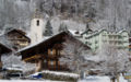
Champéry is a political municipality and a civil parish in the Monthey district in the French-speaking part of the canton of Valais in Switzerland at the end of the Val d'Illiez .
geography
The holiday resort in Valais is 1050 m above sea level. M. at the foot of the Dents du Midi and the Dents Blanches in the heart of the Portes du Soleil ski area .
At the western end of the Val d'Illiez, the Col de Bretolet is located at 1923 m above sea level. M. A ringing station for the Swiss Ornithological Institute in Sempach has been located here since 1958 .
history
Champéry is one of the oldest tourist destinations in Switzerland. With the opening of the "Dents du Midi" hotel in 1857, tourism began here. In 1864, holiday guests were able to visit the "Galerie Défago" carved into a vertical rock face for the first time and look out over the village of Champéry opposite.
In 1939 the "Société de téléphérique Champéry - Planachaux" built the first 18-person cable car in Champéry. She drove from the upper edge of the village to "Alp Planachaux", 750 m above the village. In 1987 the lift was replaced by a modern large gondola lift. In 1991 the Aigle-Ollon-Monthey-Champéry railway line, which opened in 1909, was extended to the valley station of the new gondola lift. Since then, you have been able to change directly to the large cable car cabin without stairs, which now goes up to the "Crois de Culet" above Alp Planachaux.
Between 1963 and 1987 there was an additional two-person gondola lift from the village to Alp Planachaux.
In 1964 the French-Swiss ski area Portes du Soleil was founded.
Tourism today
winter
Champéry has over 100 km of ski slopes with 1 cable car, 14 chair lifts and 26 ski lifts to Planachaux and Pointe-des-Mosettes, Pauvre-Condie and Pas-de-Condie. Champéry is part of the cross-border ski area Portes du Soleil , which offers around 650 km of ski slopes with just one ski pass. The Pas de Chavanette leads from Champéry / Planachaux to the French ski station Avoriaz .
summer
The Portes du Soleil area is popular with hikers and mountain bikers alike in summer.
population
| Population development | ||||||||||
|---|---|---|---|---|---|---|---|---|---|---|
| year | 1798 | 1850 | 1860 | 1900 | 1950 | 2000 | 2010 | 2012 | 2014 | 2016 |
| Residents | 405 | 619 | 503 | 704 | 861 | 1107 | 1276 | 1252 | 1284 | 1324 |
Attractions
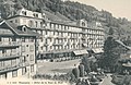
Hotel Dents du Midi

Ski area above Champéry

Champéry cable car
Center of Champery

Défago Gallery
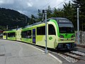
Champéry train station


literature
- Fabrice Clément: Champéry. In: Historical Lexicon of Switzerland . 2005 .
- Roland Baumgartner / Roman Weissen: 250 mountain and cable cars Switzerland Werd & Weber Verlag AG, Thun, 2016, ISBN 978-3-03818-024-1 .
Web links
- Champéry on the ETHorama platform
- Champéry municipality tourism site
Individual evidence
- ↑ Permanent and non-permanent resident population by year, canton, district, municipality, population type and gender (permanent resident population). In: bfs. admin.ch . Federal Statistical Office (FSO), August 31, 2019, accessed on December 22, 2019 .
- ↑ notrehistoire.ch: Téléphérique Champéry - Planachaux
- ↑ www.remontees-mecaniques.net: TCD2 de Champéry-Planachaux
- ↑ Port du Soleil webpage