
Chimaltenango Department
| Chimaltenango | |
|---|---|
  |
|
| Data | |
| Capital | Chimaltenango |
| population | 704,400 (calculation 2016) |
| surface | 1,979 km² |
| Population density | 356 inhabitants / km² |
| structure | 16 |
| Highest elevation | 3976 |
| ISO 3166-2 | GT-CM |
 |
|
 |
|
 |
|
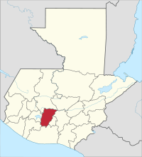
Chimaltenango is a department of Guatemala and is located in the southern mountain region of the country (Region V). It extends to 1,979 km² and has about 704,400 inhabitants. The capital of the department is Chimaltenango .
Chimaltenango is bordered by the Quiché department to the north, Baja Verapaz to the east , the Guatemala department and Sacatepéquez , Escuintla to the south, Suchitepéquez and Sololá to the west .
National nature
Chimaltenango is located in the highlands of the Sierra Madre , on the main watershed of Guatemala. To the north, the department slopes down to the valley of the Río Motagua , which flows into the Caribbean and which also forms the border with Quiché. Numerous rivers that flow into the Motagua drain the north of Chimaltenango, including the Río Agua Escondida, the Río Quisayá and the Río Pixcayá on the border with the Department of Guatemala. To the south, towards the Pacific , flow among other things the Río Madre Vieja on the border with Sololá, the Río Los Encuentros, the Río Xahá and the Río Pantaleón. Thanks to its numerous springs, Chimaltenango covers over a third of the drinking water needs of Guatemala City . The highest peaks in the department are the Acatenango (3,976 m) and Fuego (3,763 m) volcanoes in the southeast . The highlands are criss-crossed by deep gorges and valleys. The vegetation is dominated by dense pine forests in the center and in the north , and to the south these pass into subtropical moist forest. The climate in Chimaltenango is temperate, the average annual rainfall is 750 mm, the temperatures are usually between 12 and 24 degrees Celsius, it can be colder in the central highlands, warmer in the south-west and north-east.
population
About 80 percent of the population belong to the Maya ethnic group of the Cakchiquel . The area is most densely populated along the winding main thoroughfare Interamericana , which crosses the department from northwest to southeast. The approximately 570,000 inhabitants of the department live in 16 municipalities ( large communities or districts ):
As a state administrative district , the department is headed by a governor sent by the central government . The Municipios are independent regional authorities with elected mayors and representatives of the people and are subdivided into Aldeas and Pueblos ( villages ) as well as Caseríos, Parajes, Fincas, Rancherías ( hamlets and farms ).
economy
The most important branch of the economy is agriculture . Are grown coffee , beans , sugar cane and various other fruits - and vegetables . In the south, very fertile volcanic soils with a number of rivers and streams allow several harvests a year. The handicraft is important . The underdeveloped tourism is limited to services along the Interamericana and to a few historical sights such as Iximché and Mixco Viejo . The between Chimaltenango and Antigua Guatemala located recreation area Los Aposentos is rather destination for families from Guatemala City.
history
The highlands of Guatemala were long ruled by the Quiché , the Cakchiquel and the Tzutuhiles . A conflict between Quiché and Cakchiquel caused the latter to concentrate in what is now Chimaltenango, where they also built their new capital, Iximché, from 1470. In 1524 they first allied themselves with Pedro de Alvarado against the other two Mayan peoples, whereupon the Spaniards decided to settle there. Here they founded the settlement Tecpán Quauhtlemallán (about "Forest Palace") on July 25, 1524 . The name, from which the current name of Guatemala ("woodland") probably comes, was an idea of the Mexican mercenaries Alvarados.
Several Mayan uprisings followed in the region by 1530. For this reason the Spaniards had already moved their capital to Santiago de Goathemala on November 22, 1527 , today's Ciudad Vieja near Antigua Guatemala . In 1525, after months of heavy fighting and betrayal, Alvarado was able to take the Cakchiquel fortress Mixco Viejo, which is located in the very northeast of today's department. With the execution of the last tribal leader, Cahi Imox , Iximché and Chimaltenango began the three centuries of colonial times with their encomienda system.
With Sacatepéquez , Chimaltenango formed an administrative district until September 12, 1839, then both were set up as separate departments of the Republic of Guatemala . The name Chimaltenango comes from the Nahuatl words chimallí and tenango , shield and place, so roughly “place surrounded by signs”. The name probably goes back to Mexican mercenaries who were in Spanish service.
Web links
Individual evidence
- ↑ Guatemala: Departments & Cities - Population Statistics in Maps and Tables. Retrieved March 18, 2018 .
Alta Verapaz | Baja Verapaz | Chimaltenango | Chiquimula | El Progreso | Escuintla | Guatemala | Huehuetenango | Izabal | Jalapa | Jutiapa | Petén | Quetzaltenango | Quiché | Retalhuleu | Sacatepéquez | San Marcos | Santa Rosa | Sololá | Suchitepéquez | Totonicapán | Zacapa
Coordinates: 14 ° 34 ′ N , 90 ° 59 ′ W