Chräbsbach
|
Chräbsbach Krebsbach outdated: Reichenbach |
||
|
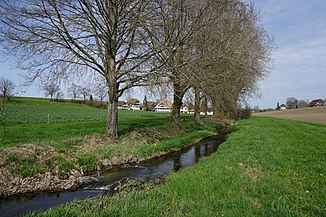
The Chräbsbach in front of Niederlindach |
||
| Data | ||
| Water code | CH : 1424 | |
| location |
Mittelland
|
|
| River system | Rhine | |
| Drain over | Aare → Rhine → North Sea | |
| source | at Meikirch 47 ° 0 ′ 5 ″ N , 7 ° 21 ′ 37 ″ E |
|
| Source height | 617 m above sea level M. | |
| muzzle | at Zollikofen in the Aare Coordinates: 46 ° 59 ′ 25 ″ N , 7 ° 27 ′ 2 ″ E ; CH1903: 600 908 / 204 355 46 ° 59 '25 " N , 7 ° 27' 2" O |
|
| Mouth height | 486 m above sea level M. | |
| Height difference | 131 m | |
| Bottom slope | 16 ‰ | |
| length | 8.2 km | |
| Catchment area | 21.37 km² | |
| Discharge at the mouth of the A Eo : 21.37 km² |
MQ Mq |
440 l / s 20.6 l / (s km²) |
| Left tributaries | Oberlindachbach | |
The Chräbsbach (also Krebsbach ; outdated: Reichenbach ) is a brook in the Swiss canton of Bern . It is a good eight kilometers long and right-hand tributary of the Aare
geography
course
The Chräbsbach rises at 617 m above sea level. M. in the Bösmattmoos in Meikirch in the open corridor.
It initially flows through fields and meadows in an east-northeast direction, curves at the northern edge of a small forest and then runs east-south-east in the area of the municipality of Wohlen near Bern, south of the village of Weissenstein. South of Schützenrain, the Chalchofebach flows into it from the left .
The Chräbsbach now moves southeast past Ortschwaben, then flows in an east-northeast direction through grassland and then passes the Niederlindach, which belongs to Kirchlindach . A little further down the stream, it is fed on its left by the Oberlindachbach .
It now runs along the south-east edge of Zollikofen , then turns sharply south and finally flows east of Reichenbach at an altitude of 486 m above sea level. M. from the right into the Aare.
Its 8.2 km long run ends about 131 meters below its source, so it has an average bed gradient of 16 ‰.
Catchment area
The 21.37 km² catchment area of the Chräbsbach is located in the western central plateau and is drained via the Aare and the Rhine to the North Sea.
It consists of 22.2% wooded area , 68.5% agricultural area , 8.9% settlement area , 0.3% water area and 0.1% unproductive areas.

The mean height of the catchment area is 620 m above sea level. M. , the minimum height is 485 m above sea level. M. and the maximum height at 788 m above sea level. M.
Tributaries
- Chalchofebach ( left ), 1.5 km
- Oberlindachbach ( left ), 4.8 km, 3.63 km², 70 l / s
Hydrology
At the confluence of the Chräbsbach into the Aare, its modeled mean flow rate (MQ) is 440 l / s. Its discharge regime type is pluvial inférieur and its discharge variability is 25.
The modeled monthly mean discharge (MQ) of the Chräbsbach in l / s


Data
The amount of doping water is 91 liters per second.
literature
- Eduard M. Fallet: Bremgarten: Reading and presentation book on the history of the parish of Bremgarten and the communities of Zollikofen, Bremgarten City Court and Bremgarten near Bern . Paul Haupt Verlag, Bern 1991, ISBN 3-258-04387-6 . Section: The Chräbsbach, pages: 175 following
Web links
Individual evidence
- ↑ a b Geoserver of the Swiss Federal Administration ( information )
- ↑ Self-measurement on the geoserver of the Swiss Federal Administration ( notes )
- ↑ a b c d Topographical catchment areas of Swiss waters: sub-catchment areas 2 km². Retrieved September 7, 2018 .
- ↑ Bern: Reichenbach Castle - Le château de Reichenbach, Zollikofen
- ↑ "Hidden behind the mean values" - the variability of the discharge regime , p. 119
- ↑ The discharge variability describes the extent of the fluctuations in the mean discharge of individual years around the long-term mean discharge value.
- ↑ https://www.wada.bve.be.ch/geoportal/trosec/pegelblatt/L051.pdf
