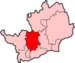
City and District of St Albans
| City and District of St Albans | |
|---|---|
 Location in Hertfordshire |
|
| status | Borough and City |
| region | East of England |
| Administration County | Hertfordshire |
| Administrative headquarters | St Albans |
| surface | 161.18 km² (205.) |
| Residents | 132,300 (142.) |
| ONS code | 26UG |
| Website | www.stalbans.gov.uk |
City and District of St Albans is an administrative district in Hertfordshire , England .
Belong to the district
- The City of St Albans (approx. 58,000 inhabitants)
- the city of Harpenden (approx. 27,600 inhabitants)
- the parishes of Colney Heath , Harpenden Rural, London Colney , Redbourn , St Michael , St Stephen (including Chiswell Green and Bricket Wood ), Sandridge and Wheathampstead .
The unusual name for a district arose from the fact that there are two urban areas and several localities in its area. Usually districts in which a city is located are only named City of (e.g. City of Peterborough ).
The district was formed in 1974 through a merger of St Albans City Council , Harpenden Urban District Council and St Albans Rural District Council . While the official name of the District Council is St Albans District Council , the name St. Albans City & District is used on all vehicles, letterheads and the website .
Coordinates: 51 ° 47 ′ N , 0 ° 20 ′ W