
Clemgia
| Clemgia | ||
 The Clemgia flows into the Inn near Scuol |
||
| Data | ||
| Water code | CH : 45 | |
| location | Community of Scuol , District of Inn , Canton of Graubünden , Switzerland | |
| River system | Danube | |
| Drain over | Inn → Danube → Black Sea | |
| source | in a small mountain lake on the southern slope of Piz Cotschen 46 ° 38 ′ 43 ″ N , 10 ° 23 ′ 46 ″ E |
|
| Source height | 2582 m | |
| muzzle | at Scuol in the Inn Coordinates: 46 ° 47 '23 " N , 10 ° 17' 39" E ; CH1903: 817 982 / 186 029 46 ° 47 '23 " N , 10 ° 17' 39" O |
|
| Mouth height | 1172 m | |
| Height difference | 1410 m | |
| Bottom slope | 61 ‰ | |
| length | 23 km | |
| Catchment area | 110.63 km² | |
| Discharge A Eo : 110.63 km² at the mouth |
MQ Mq |
3.47 m³ / s 31.4 l / (s km²) |
| Right tributaries | Ouch Sesvenna | |
 Upper course of the Clemgia |
||
The Clemgia (pronunciation ) is an approximately 23 kilometer long tributary of the Inn in the canton of Graubünden .
The source is located on the southern slope of Piz Cotschen and north of Piz Terza in a small mountain lake near the border near the border with Italian South Tyrol .
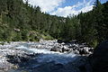
The stream flows from the headwaters via Tamangur in the direction of S-charl , a hamlet of Scuol. Shortly thereafter, the Clemgia joins the Aua Sesvenna and the creeks of the Val Tavrü and the Val Mingèr and then flows north along the border of the Swiss National Park to 1385 m above sea level. M. deepest point of the national park.
Then the Clemgia falls with a height difference of 200 m for 2 kilometers through the Clemgia Gorge towards the Inn, where it near Scuol at 1172 m above sea level. M. opens.

Between S-charl and the gorge
Just before the gorge

The Clemgia Gorge


Web links
Individual evidence
- ↑ a b c Geoserver of the Swiss Federal Administration ( information )
- ↑ a b Topographical catchment areas of Swiss waters: sub-catchment areas 2 km². Retrieved June 9, 2019 .