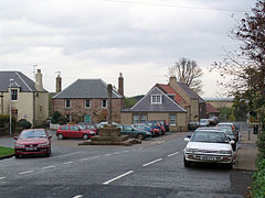
Cockburn spath
| Cockburn spath | ||
|---|---|---|
| Cockburnspath Market Cross | ||
| Coordinates | 55 ° 56 ′ N , 2 ° 22 ′ W | |
|
|
||
| Residents | 233 (1971 census) | |
| administration | ||
| Post town | COCKBURNSPATH | |
| ZIP code section | TD13 | |
| prefix | 01890 | |
| Part of the country | Scotland | |
| Council area | Scottish Borders | |
| British Parliament | Berwickshire, Roxburgh and Selkirk | |
| Scottish Parliament | Ettrick, Roxburgh and Berwickshire | |
Cockburnspath , outdated Colbrandspath , often Co'path for short , is a town in the Scottish Council Area Scottish Borders . It is located in the northeast of the region about eleven kilometers southeast of Dunbar and 25 km northwest of Berwick-upon-Tweed in the traditional county of Berwickshire . A few hundred meters to the east is the North Sea coast . The village of Oldhamstocks, about three kilometers to the west, is already in the East Lothian Council Area .
history
For centuries, the village was owned by the Earls of Dunbar , the royal family and the Earls of Home . Cockburnspath and the surrounding area were dominated by agriculture in the past. Fishing was pursued in the neighboring hamlet of Cove .
Since the 14th century the fortress Castle of Dunglass (not to be confused with Dunglass Castle in West Dunbartonshire ) was the seat of the Earls of Home. After this was destroyed in 1548, reconstruction began in 1603. To this day, no remains of the fortress have survived. Construction of the stately Dunglass House on the same site was completed in 1811. The builder was James Hall, 4th Baronet . After a fire, the building was demolished in the late 1950s. The nearby Dunglass Viaduct is classified as a monument of the highest Scottish monument category A.
To the south lies the Cockburnspath Tower, which is now in ruins . The Tower House dates from the 15th century. It may have served as a template for Ravenswood Castle in Walter Scott's novel The Bride of Lammermoor .
A geological formation in the region, Siccar Point , was important evidence of the incipient modern geology, which was largely founded by James Hutton .
In the 1880s, the Glasgow Boys collective established an artists' colony in Cockburnspath. While the population of Cockburnspath fluctuated between 1100 and 1200 in the 18th century, in 1961 it was 261. As part of the census survey in 1971, 233 people were counted in the village.
traffic
Cockburnspath is just west of the A1 ( London - Edinburgh ). The village is also the eastern end point of the Southern Upland Way long-distance hiking trail . With the Edinburgh Airport is an international airport some 60 km to the west.
Individual evidence
- ^ A b c Cockburnspath in: FH Groome: Ordnance Gazetteer of Scotland: A Survey of Scottish Topography, Statistical, Biographical and Historical. , Grange Publishing, Edinburgh, 1885.
- ↑ a b Entry in the Gazetteer for Scotland
- ↑ Entry on Dunglass House in Canmore, the database of Historic Environment Scotland (English)
- ↑ Listed Building - Entry . In: Historic Scotland .
- ↑ Entry on Cockburnspath Tower in Canmore, the database of Historic Environment Scotland (English)
- ^ Information in the Gazetteer for Scotland
- ^ Course of the Southern Upland Way

