
Col de Sommeiller
| Col de Sommeiller | |||
|---|---|---|---|
 Mountain lake at the Col de Sommeiller |
|||
| Compass direction | north | south | |
| Pass height | 3000 m | ||
| region | Department of Savoie | region Piedmont | |
| expansion | Alpine route (alpine transition) | dirt road | |
| Lock | Fri - Sun 9 a.m. to 5 p.m. for cars | ||
| Mountains | Cottian Alps | ||
| profile | |||
| Denzel scale | SG 4 | ||
| map | |||
|
|||
| Coordinates | 45 ° 8 '8 " N , 6 ° 50' 47" E | ||

The Col de Sommeiller (or Colle Sommeiller ) is a pass in the Italian Alps in Piedmont . It is located in the Mont Cenis massif on the border between France and Italy near the Mont Cenis tunnel . The special thing about the pass is the fact that after the access to Mont Chaberton was finally closed around the year 2000, the high plateau located at 2996 meters just below the pass was the highest point in the Alps until June 2007 acted that could legally be approached by two-lane vehicles - now this is the mountain station of the Bontadini lift near Cervinia, which is only open to traffic at certain events.
The pass is named after the Italian engineer Germain Sommeiller (born March 15, 1815 in Saint-Jeoire, † July 11, 1871 in Saint-Jeoire), who u. a. is responsible for the construction of the 12 km long Fréjus tunnel between Bardonecchia (Italy) and Modane (France).
Today, access to the Col de Sommeiller is almost only possible with off-road vehicles. The coarsely graveled, sometimes very narrow road is located in a high alpine environment, so that it should only be used by experienced drivers ( SG 4 ). There is a driving ban for vehicles above the Rifugio Scarfiotti from Friday to Sunday from 9:00 a.m. to 5:00 p.m. (as of July 2009).
This is a former ski area, which was abandoned after a serious avalanche accident in the 1960s . Since then, the path has only been maintained sporadically. Once a year, on the occasion of the Stella Alpina motorcycle meeting , the path is cleared of snow and somewhat repaired. The Stella Alpina always takes place on the second Sunday in July and is the highest motorcycle meeting in the world. Before this time, due to the snow conditions in the higher regions, it is very unlikely to be able to reach the top of the pass. The first week of September has proven to be the best time to visit.
The path leads from Bardonecchia towards Rochemolles , past the Lac Rochemolles reservoir and the Rifugio Scarfiotti and then gains altitude in numerous serpentines. In the upper part, the hairpin bends are partly heavily washed out, so that driving with conventional cars is difficult to imagine today. In some cases, larger vehicles have to be reversed several times in the bends.
The path ends on a high plateau. There you will find a lake with a water level that varies greatly over the year. Also on the high plateau was the Rifugio Ambin , a former hotel (or weather station), which was demolished between September 2004 and October 2005. On the south-eastern edge of the high plateau there is a hill on which several flagpoles stand ( 3050 m ). This is the flag hill , the destination of numerous motorcycle and off-road vehicle drivers from all over Europe, for whom driving on this hill was a challenge. Due to a wooden barrier between the plateau and the lake, the flag hill is no longer accessible today. A virtual GeoCache has been placed on the flag hill since January 22, 2004 (see web links).
The actual summit Punta Sommeiller is 3333 m high and can only be reached on foot over a steep gravel field.

The former weather station at Col de Sommeiller
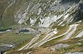
View from the serpentines down to the Rifugio Scarfiotti

