Colniza
| Município de Colniza Colniza |
||
|---|---|---|
|
|
||
| Coordinates | 9 ° 25 ′ S , 59 ° 1 ′ W | |
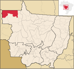
 Location of the municipality in the state of Mato Grosso Location of the municipality in the state of Mato Grosso
|
||
| Symbols | ||
|
||
| founding | 26th November 1998 (age 21) | |
| Basic data | ||
| Country | Brazil | |
| State | Mato Grosso | |
| ISO 3166-2 | BR-MT | |
| structure | 2 districts | |
| height | 131 m | |
| climate | tropical, Aw | |
| surface | 27,946.1 km² | |
| Residents | 26,381 (2010) | |
| density | 0.9 Ew. / km² | |
| estimate | 38,582 (July 1, 2019) | |
| Parish code | IBGE : 5103254 | |
| Post Code | 78.335-000 | |
| Telephone code | (+55) 66 | |
| Time zone | UTC −4 | |
| Website | colniza.mt (Brazilian Portuguese) | |
| politics | ||
| City Prefect | Esvandir Antonio Mendes (2017-2020) | |
| Political party | PSB | |
| Culture | ||
| City festival | November 26th (founding day) | |
| economy | ||
| GDP | 528,694 thousand R $ 14,621 R $ per person (2017) |
|
| HDI | 0.611 (2010) | |
Colniza , officially Portuguese Município de Colniza , is a municipality in the northwest of the Brazilian state of Mato Grosso . It emerged from a rural settlement project in 1998 and has a large community area of around 27,946.1 km². The population was estimated at 38,582 residents as of July 1, 2019, who are called Colnizenser ( colnizenses ). The actual city of Cidade de Colniza administers an area the size of Brandenburg, arithmetically resulting in a population density of 0.9 inhabitants per km². It borders the state of Amazonas to the north and Rondônia to the west . The distance to the capital Cuiabá is 1065 km. Statistically, it ranks 23rd out of the state's 141 municipalities. A large part of the economy is based on the timber industry , Colniza shows the largest deforestation area in the rainforest.
It is notorious for having one of the highest murder rates in Mato Grosso and massacres of the population such as the Colniza massacre in 2017.
geography
Surrounding communities are Cotriguaçu , Aripuanã , Rondolândia , Apuí as well as Novo Aripuanã (state of Amazonas) and Machadinho d'Oeste (Rondônia).
The biome is the Amazon rainforest (Amazônia), the climate is tropical, Aw according to the Köppen and Geiger climate classification . The average temperature is 25.5 ° C. The average rainfall is 2049 mm per year.
By the municipality for the flow Amazon basin belonging more important Rio Canama , aripuanã river , Rio Salvação , Rio Guariba , Rio Água Branca , Rio Roosevelt and Rio Madeirinha .
It also includes some nature reserves such as the Parque Estadual Igarapés do Juruena and indigenous territories such as Terra Indígena Kawahiva do Rio Pardo .
Population development
| year | Residents | city | country |
|---|---|---|---|
| 1991 | 2,190 | ||
| 2000 | 10,270 | 3,850 | 6,420 |
| 2010 | 26,381 | 14,987 | 11,394 |
| 2019 | 38,582 | ? | ? |
 |
|||
Source:
Web links
- City Prefecture website , Prefeitura Municipal (Brazilian Portuguese)
- City Council website , Câmara Municipal (Brazilian Portuguese)
- Pronunciation example
Individual evidence
- ↑ Colnitsa - Panorama. IBGE , accessed July 21, 2020 (Brazilian Portuguese).
- ^ Nine farm workers murdered in Brazil. In: ln-online.de. LN - Lübecker Nachrichten, April 23, 2017, accessed on July 21, 2020 .
- ↑ Colniza climate: average temperature, weather by month, Colniza weather averages. In: de.climate-data.org. Retrieved July 21, 2020 .
- ^ Atlas do Desenvolvimento Humano do Brasil: Colniza . Retrieved July 21, 2020 (Portuguese).

