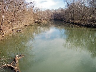
Conococheague Creek, Maryland
| Conococheague Creek | ||
|
Conococheague Creek near its mouth at Williamsport, Maryland in the Chesapeake and Ohio Canal National Historical Park |
||
| Data | ||
| GNIS ID | US : 592371 | |
| location | Pennsylvania and Maryland , USA | |
| River system | Potomac River | |
| Drain over | Potomac River → Delaware Bay | |
| source | in Franklin County, Pennsylvania 36 ° 36 ′ 4 " N , 77 ° 49 ′ 45" W. |
|
| muzzle | in the Potomac River near Williamsport Coordinates: 39 ° 36 '4 " N , 77 ° 24' 21" W 39 ° 36 '4 " N , 77 ° 24' 21" W. |
|
| Mouth height |
101 m
|
|
| length | 129 km | |
| Catchment area | 1470 km² | |
| Left tributaries | Conococheague Creek | |
Conococheague Creek is a free flowing tributary of the Potomac River , which rises in Pennsylvania and flows into the Potomac River at Williamsport , Maryland . It has a length of 129 km, of which 92 km in Pennsylvania and 37 km in Maryland. The catchment area covers an area of 1470 km², of which only 12% (170 km²) are in Maryland.
The name Conococheague is borrowed from the Leni-Lenape language : the word òk'chaxk'hanna means "a river that winds a lot". The river, then known as Connogochegue , formed the northernmost area along the Potomac, in which Congress, with the Residence Bill of 1790, approved the establishment of federal territory in the District of Columbia . By proclamation of President George Washington , the district was established at the southern end of the range, near the "Eastern Branch", which was later renamed the Anacostia River .
The watershed between Conococheague Creek and Conodoguinet Creek serves as the boundary between the Hagerstown Valley and the Cumberland Valley .
Above the mouth of the West Branch
The Conococheague Creek is sometimes referred to as the East Branch Conococheague Creek above the confluence of the West Branch. With a length of 85.5 km, the "East Branch" is 11 km shorter than the West Branch. It rises in the South Mountains in south-central Pennsylvania, in northwest Adams County between the East Big Flat Ridge and Piney Mountain. The creek flows southwest, turns west in Caledonia State Park, and passes Fayetteville into the Great Appalachian Valley . He turns southwest at Chambersburg and passes Greencastle west.
Between Fayetteville and the confluence of Back Creek near Williamson, the river is heavily polluted by surface runoff from agriculture. Over three decades, the numbers went native fish such as yellow perch , eels , Bachzwergdöbel , Pomoxis , rock bass and Saugkarpfenart Catostomus commersonii back, because the deteriorating water quality due to sedimentation at the base limited the Ablaichung this fish species a strong. On the other hand, there was an increase in crayfish in parts of the river , but their nutritional value is doubtful due to the pollution of the water.
Below the mouth of the West Branch
After the confluence of the West Branch at Greencastle, the Conococheague Creek continues its way south to Maryland and flows into the Potomac River at Williamsport, where the Great Philadelphia Wagon Road crossed the river at William's Ferry and continued to Winchester , Virginia . At this point Edward Braddock's troops crossed the river after leaving Frederick and moving to Winchester.
See also
supporting documents
- ↑ a b c U.S. Geological Survey. National Hydrography Dataset high-resolution flowline data. The National Map
- ↑ Search Results . talk-lenape.org.
Web links
- Conococheague Creek, Maryland, in the Geographic Names Information System of the United States Geological Survey
- Conococheague Creek at Maryland Department of the Environment


