
Crown Point (New York)
| Crown Point | |||
|---|---|---|---|
 View from the west of the bridge at Crown Point |
|||
| Location in New York | |||
|
|||
| Basic data | |||
| Foundation : | March 23, 1786 | ||
| State : | United States | ||
| State : | new York | ||
| County : | Essex County | ||
| Coordinates : | 43 ° 57 ′ N , 73 ° 29 ′ W | ||
| Time zone : | Eastern ( UTC − 5 / −4 ) | ||
| Residents : | 2,024 (as of 2010) | ||
| Population density : | 10.2 inhabitants per km 2 | ||
| Area : | 212.1 km 2 (approx. 82 mi 2 ) of which 197.5 km 2 (approx. 76 mi 2 ) are land |
||
| Height : | 277 m | ||
| Postal code : | 12928 | ||
| Area code : | +1 518 | ||
| FIPS : | 36-19246 | ||
| GNIS ID : | 0978879 | ||
| Website : | www.co.essex.ny.us/CrownPoint.asp | ||
 View from south on Crown Point 1760 by Thomas Davies |
|||

Crown Point is a town on the eastern tip of Essex County (New York) in Adirondack Park in the USA with 2,024 inhabitants (Census 2010).
history
During the colonial period and during the American Revolutionary War , Crown Point was of strategic importance, as it was a fortified position on the west bank of Lake Champlain only 15 miles north of Fort Ticonderoga and thus only a day's journey away.
After the failure of the American invasion of Canada (1775) , the site was the northernmost point under American control. During the British Saratoga campaign in 1777 , British General John Burgoyne stationed a storage facility here for the Battle of Ticonderoga .
geography
The eastern city limit, the shores of Lake Champlain, is the border with Vermont ( Addison County ). A bridge on US Highway 17 connects Crown Point with Vermont.
The town has an area of 212.1 km 2 . 197.5 km 2 of this is land and 14.6 km 2 is water. Crown Point locations and other geographic features include:
- Bulwagga Bay - a bay between the Crown Point Peninsula and the county's mainland
- Burdick Crossing - a hamlet in the northeastern part of town, south of Crown Point on County Road 48
- Cold Spring Park - a hamlet in the northeast part of the city on 7 County Road
- Crown Point - a village in the eastern part of the city on US Highway 9N . The Crown Point Green Historic District was added to the National Register of Historic Places in 2015 .
- Crown Point - a peninsula at the south end of Lake Champlain and the site of several historical fortifications, the Crown Point State Historic Site
- Crown Point Center - a hamlet west of Factoryville at the intersection of County Roads 2 and 7
- Eagle Lake - a lake in the southwest of the town
- Factoryville - a hamlet west of Crown Point
- Ironville - a hamlet in the southern part of the city with the Ironville Historic District
- Penfield Pond - a lake on the southern edge of the town
- Putts Creek Wildlife Management Area - a wildlife sanctuary north of the village of Crown Point
population
According to the 2000 census , Crown Point has 2,119 residents, 797 households, and 579 families. The population density is 10.7 inhabitants / km².
There are 797 households of which 33.9% have children under the age of 18, 58.2% are couples and 8.3% are single mothers. 21.3% of all households are single households, almost half of them are over 65 years of age. 28.0% of the population are under 18 years old and 14.4% are over 65.
The median income per household is $ 33,958 and the median income per family is $ 39,853. Males have a median income of $ 31,106 and females $ 20,074. The per capita income for the city is $ 16,692. 14.6% of all residents, 10.8% of all families, 20.9% of all under 18 year olds and 9.6% of all over 65 year olds live below the poverty line .
gallery
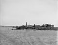
Lake Champlain , NY, Crown Point Lighthouse between 1890 and 1910.
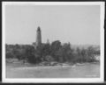
Crown Point Lighthouse, Lake Champlain , NY circa 1907.

The embarkation of Montgomery's troops at Crown Point. Richard Montgomery and troops on the shore at Crown Point, New York , on the way to the invasion of Canada (1775) . Drawn by Sydney Adamson. Halftone print engraved by JW Evans. Printed in 1902.

Ruins of Fort Crown Point , NY circa 1902.

Ruins of Fort Crown Point , circa 1907.

Ruins of Fort Crown Point , between 1900 and 1906.

Fort Henry from Fort Frederic , Crown Point, NY Photograph shows a view across Lake Champlain to hills in the distance on December 23, 1902.


