
Cruschetta
| Cruschetta
(S-charljoch, S-charljöchl, Passo della Crocetta) |
|||
|---|---|---|---|
 The Swiss side with Piz Pisoc |
|||
| Compass direction | North | south | |
| Pass height | 2291 m | ||
|
Lower Engadine , Graubünden , Switzerland |
Vinschgau , South Tyrol , Italy |
||
| Watershed | Clemgia → Inn → Danube → Black Sea | Valgarola → Rome → Adige → Po → Mediterranean | |
| Valley locations | Scuol ( 1243 m above sea level ) / S-charl ( 1810 m above sea level ) | Taufers ( 1240 m slm ) | |
| expansion | Mountain path | ||
| Mountains | Sesvenna group, Eastern Alps | ||
| Map (Graubünden) | |||
|
|||
| Coordinates , ( CH ) | 46 ° 41 '28 " N , 10 ° 23' 39" O ( 826 024 / 175 345 ) | ||

The Cruschetta , in German also S-charljoch or S-charljöchl , in Italian called Passo della Crocetta , is 2291 meters above sea level. high pass in the Alps .
geography
The pass lies in the Sesvenna group and connects the villages of S-charl (1810 m above sea level) and Scuol (1243 m above sea level) in the canton of Graubünden , Switzerland , with the village of Taufers in the Münstertal (1240 m above sea level) above sea level) in South Tyrol , Italy .
A mountain hiking trail leads over the pass. It is impassable for vehicles due to the steep and rocky terrain. From Taufers you get to the Avignatal, a left side valley of the Munster valley. From there the short but steep ascent leads past the Jöchl Hut to the top of the pass (2291 m above sea level), near which the Valgarolebach rises. on which a crucifix and a boundary stone dated 1861 stand. There is a small pond on the Swiss side of the pass. The descent is through Val Plazèr into Val S-charl , where the pass path joins the mountain paths of the Pass da Costainas and the Fuorcla Funtana da S-charl . The path leads along the Clemgia river to the mountain village of S-charl and from there out of the valley to Scuol. The skyline is shaped (from the top of the pass) on the Swiss side by Piz Pisoc (3173 m above sea level), on the Italian side by the Ortler (3905 m above sea level).
gallery

Italian side with Val d'Avigna

Italian side with Ortler
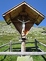
Crucifix on the top of the pass

Pass summit with Piz Pisoc

Swiss side: Val S-charl with Piz Madlain


Literature and web links
- Paul Eugen Grimm: Taufers. In: Historical Lexicon of Switzerland .
- Tour description Scuol Tourismus