
Piz Pisoc
| Piz Pisoc | ||
|---|---|---|
 Piz Pisoc (highest peak), view from the north. To the left of it the subordinate peaks of Piz Lavetscha and Piz Clemgia , to the right of it the somewhat smaller Piz dals Vadès and on the right edge of the picture Piz Zuort . |
||
| height | 3173.3 m above sea level M. | |
| location | Scuol , Switzerland | |
| Mountains | Sesvenna group | |
| Dominance | 10.2 km → Piz Sesvenna | |
| Notch height | 922 m ↓ Pass da Costainas | |
| Coordinates | 817 057 / 180 972 | |
|
||
| rock | dolomite | |

The Piz Pisoc (pronunciation in Vallader : ) is 3173.3 m above sea level. M. the highest point of the Swiss National Park and after Piz Sesvenna the second highest mountain on the right side of the Lower Engadine . The summit is in the municipality of Scuol . Neighboring mountains are the Piz dals Vadès ( 3140 m above sea level ), the Piz Zuort ( 3119 m above sea level ) and the Piz Mingèr ( 3081 m above sea level ). The prominence of the summit is 922 m ( Pass da Costainas / Piz Sesvenna).
Ascent
The route leads from the hamlet of Fontana in Tarasp up through the Val Zuort . From approx. 2640 m above sea level M. leads you through a gully at risk of falling rocks to the ridge between the Piz dals Vadès and the Piz Pisoc. From there to the summit, the route is marked in red and white. The level of difficulty is T5 / II .
The rock of Piz Pisoc is brittle.
geology
The Piz Pisoc and the neighboring peaks lie south of the Engadine window and are part of the geological S-charl ceiling . The peaks belong to the Lower Engadine Dolomites ( east-alpine sediment cover ) , corresponding to the most important mountain-forming rock dolomite . The rock formation took place in the Triassic .
The Piz Pisoc belongs to a summit corridor typical of the Eastern Alps : Many of the peaks to the right of the Inn within a radius of about 10 km are about the same height, namely around 3100 m above sea level. M.
National park
The Piz Pisoc is the highest point in the Swiss National Park. The eastern and southern flanks of Piz Pisoc drop steeply into Val S-charl and Val Mingèr : the summit would therefore be practically inaccessible from the park area, even apart from the route restrictions in the park. At 1382 m above sea level M. is also the lowest point of the national park on Piz Pisoc, namely on the Clemgia below the Plan da Funtanas , just before the start of the Clemgia Gorge.
The rest
The Pisoc massif is about 1500 m above sea level. M. is crossed under by a tunnel of the Engadine power plants .
The mountain was recorded in the maps of the Atlas Tyrolensis from 1774 as "Biz Bisogg". At that time it was the border mountain between Tyrol and Graubünden , as Tarasp was then still a Tyrolean exclave .
panorama

Picture gallery
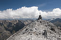
Summit cross of Piz Pisoc. On the right edge of the picture, approx. 11 km away, the Piz Sesvenna on the Italian border.

Piz Pisoc with snow, from the Motta Naluns (highest peak on the left). Behind the gondola the Val Zuort (classic ascent).
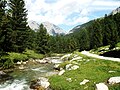
View from the southeast, Val S-charl above S-charl . Piz dals Vadès on the left, Piz Pisoc on the right. In the foreground pine forest .

S-charl, in the background Piz Mingèr (left), Piz dals Vadès (center) and Piz Pisoc (right).


Web links
Individual evidence
- ↑ Jachen Curdin Arquint (1964). Vierv Ladin . Tusan: s is voiced between vowels.
- ↑ Romedie Reinalter (2004). On the flora of the sedimentary areas in the vicinity of the South Ratian Alps, Livignasco, Bormiese and Engiadin'Ota (Switzerland-Italy). Birkhäuser, Basel.
- ↑ The geological window of the Lower Engadine ( Memento of the original from December 18, 2015 in the Internet Archive ) Info: The archive link has been inserted automatically and has not yet been checked. Please check the original and archive link according to the instructions and then remove this notice. (PDF; 445 kB), accessed on July 20, 2012.
- ↑ R. Trümpy et al. (1997). Explanations of the geological map 1: 500000 of the Swiss National Park.